IMAGES TAKEN NEAR TO
Leconfield Road, BEVERLEY, HU17 7LJ
Introduction
This page details the photographs taken nearby to Leconfield Road, HU17 7LJ by members of the Geograph project.
The Geograph project started in 2005 with the aim of publishing, organising and preserving representative images for every square kilometre of Great Britain, Ireland and the Isle of Man.

There are currently over 7.5m images from over14,400 individuals and you can help contribute to the project by visiting https://www.geograph.org.uk
Image Map
Images are licensed for reuse under creativecommons.org/licenses/by-sa/2.0
Notes
- Clicking on the map will re-center to the selected point.
- The higher the marker number, the further away the image location is from the centre of the postcode.
Image Listing (16 Images Found)
Images are licensed for reuse under creativecommons.org/licenses/by-sa/2.0
Image
Details
Distance
1
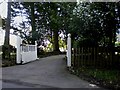
Entrance to Leicester Lodge
This shows the entrance to Leicester Lodge, a large residential property, near the crossroads of the B1248 with the Cherry Burton to Leconfield road.
Image: © Dr Patty McAlpin
Taken: 31 Jul 2009
0.09 miles
2
Junction of B1248 and Main Street, Cherry Burton
Image: © Chris
Taken: 7 Feb 2015
0.11 miles
3
Cycle path crossing Malton Road
National Cycle Network routes 1 and 66 cross the road and turn into Cherry Burton with a path to Leconfield continuing ahead.
Image: © DS Pugh
Taken: 3 Sep 2023
0.12 miles
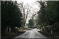
4
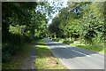
Crossroads near Cherry Burton
The B1248 is running across this road from Cherry Burton. It is raining because it is a bank holiday weekend.
Image: © Bill Boaden
Taken: 3 Jun 2012
0.12 miles
5
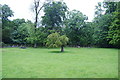
Corner of a sheep field
Part of the estate belonging to the Hall at Cherry Burton.
Image: © Bill Boaden
Taken: 3 Jun 2012
0.13 miles
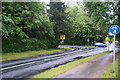
6

Fields beside Malton Road
Looking across The Park from Main Street near Cherry Burton.
Image: © DS Pugh
Taken: 27 Apr 2024
0.13 miles
7
Bus stop on Main Street
National Cycle Network routes 1 and 66 run along here.
Image: © DS Pugh
Taken: 3 Sep 2023
0.15 miles
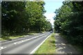
8
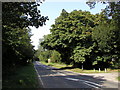
The B1248 road to Cherry Burton
This is the B1248 (the 'binary road' perhaps?!) from Beverley to Malton. The turning to Cherry Burton is just a little further up the road from here on the left. The road in the seventies was very 'quiet', but is now far more heavily used due to far more people living out in this area now. The tree is a marvellous horse chestnut which has been here for many, many years.
Image: © Andy Beecroft
Taken: 11 Sep 2006
0.19 miles
9
Rail trail near Cherry Burton golf club
Looking along the Market Weighton to Beverley path on the former York to Beverley railway line.
Image: © DS Pugh
Taken: 20 Jun 2020
0.21 miles
10
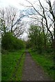
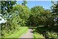
Path beside Cherry Burton golf course
A cycle path between Market Weighton and Beverley along the former York to Hull railway line.
Image: © DS Pugh
Taken: 27 Apr 2024
0.21 miles