IMAGES TAKEN NEAR TO
Woodhall Way, BEVERLEY, HU17 7JU
Introduction
This page details the photographs taken nearby to Woodhall Way, HU17 7JU by members of the Geograph project.
The Geograph project started in 2005 with the aim of publishing, organising and preserving representative images for every square kilometre of Great Britain, Ireland and the Isle of Man.

There are currently over 7.5m images from over14,400 individuals and you can help contribute to the project by visiting https://www.geograph.org.uk
Image Map
Images are licensed for reuse under creativecommons.org/licenses/by-sa/2.0
Notes
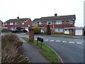
- Clicking on the map will re-center to the selected point.
- The higher the marker number, the further away the image location is from the centre of the postcode.
Image Listing (35 Images Found)
Images are licensed for reuse under creativecommons.org/licenses/by-sa/2.0
Image
Details
Distance
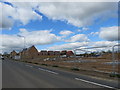
1
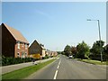
Woodhall Way new-builds to the left
Was an arable field now another housing estate, those fronting onto Woodhall Way are now lived in but they are still building behind
Image: © Martin Dawes
Taken: 6 Jun 2016
0.01 miles
2
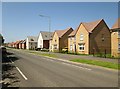
Looking up Woodhall Way
The new development on the right, they are still building at the back of these houses.It was a long narrow arable field between Woodhall Way and the bypass.
Image: © Martin Dawes
Taken: 6 Jun 2016
0.06 miles
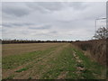
3
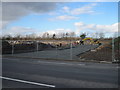
Entrance into new housing estate
This long narrow field between Woodhall Way and the bypass is now becoming a building site for a new crop of houses.
Image: © Martin Dawes
Taken: 16 Feb 2014
0.06 miles
4
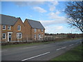
New Builds on Woodhall Way
Inevitable with the bypass on the other side of the field, the fight has been long, it is the last land to be filled by housing on this section of bypass.
Image: © Martin Dawes
Taken: 16 Feb 2014
0.06 miles
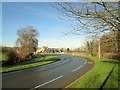
5
The expansion of a town
A field last year, now the show houses are open and bases are down and we have to walk a bit further to see open countryside.
Image: © Martin Dawes
Taken: 2 May 2014
0.09 miles

7
Another Greenfield site to become houses
This long narrow field between Woodhall Way to the right and Beverley Bypass to the left has been fought over for years, planning has been refused on a number of occasions, but this time the government official has overruled the local parish and county councils.
Image: © Martin Dawes
Taken: 13 Apr 2013
0.11 miles
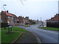
9
The bend on Woodhall Way Molescroft Beverley
Playing field to the left, medical centre to the right. Eastern end of the new housing estate still under construction, outward facing houses now lived in centre left.
Image: © Martin Dawes
Taken: 16 Feb 2016
0.12 miles
10
Houses on St Leonards Road, Beverley
Showing position of Postbox No. HU17 269.
See Image] for postbox.
Image: © JThomas
Taken: 28 Dec 2019
0.13 miles