IMAGES TAKEN NEAR TO
West Street, BEVERLEY, HU17 5LR
Introduction
This page details the photographs taken nearby to West Street, HU17 5LR by members of the Geograph project.
The Geograph project started in 2005 with the aim of publishing, organising and preserving representative images for every square kilometre of Great Britain, Ireland and the Isle of Man.

There are currently over 7.5m images from over14,400 individuals and you can help contribute to the project by visiting https://www.geograph.org.uk
Image Map
Images are licensed for reuse under creativecommons.org/licenses/by-sa/2.0
Notes
- Clicking on the map will re-center to the selected point.
- The higher the marker number, the further away the image location is from the centre of the postcode.
Image Listing (48 Images Found)
Images are licensed for reuse under creativecommons.org/licenses/by-sa/2.0
Image
Details
Distance
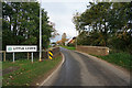
3
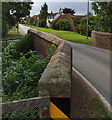
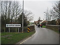
Little Leven
Looking along West Street; the wall in the foreground is the parapet of Causeway Bridge which carries the road over Burshill & Barff Drain.
Image: © Paul Harrop
Taken: 16 Aug 2008
0.05 miles
10
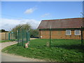
Yorkshire Water site on West Street Leven
Image: © Martin Dawes
Taken: 18 Apr 2018
0.13 miles