IMAGES TAKEN NEAR TO
The Vineyards, BEVERLEY, HU17 5LD
Introduction
This page details the photographs taken nearby to The Vineyards, HU17 5LD by members of the Geograph project.
The Geograph project started in 2005 with the aim of publishing, organising and preserving representative images for every square kilometre of Great Britain, Ireland and the Isle of Man.

There are currently over 7.5m images from over14,400 individuals and you can help contribute to the project by visiting https://www.geograph.org.uk
Image Map
Images are licensed for reuse under creativecommons.org/licenses/by-sa/2.0
Notes
- Clicking on the map will re-center to the selected point.
- The higher the marker number, the further away the image location is from the centre of the postcode.
Image Listing (94 Images Found)
Images are licensed for reuse under creativecommons.org/licenses/by-sa/2.0
Image
Details
Distance
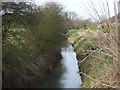
2

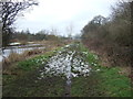
Barff Drain
Looking towards Carr Lane bridge.
Image: © Jonathan Thacker
Taken: 5 Jan 2018
0.10 miles
3
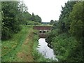
Barff Drain, Leven
Looking along Barff Drain on the western edge of Leven. The bridge ahead carries the Leven Canal over the top of the drainage channel.
Image: © Graham Robson
Taken: 29 Jun 2017
0.10 miles
5
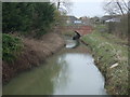
Drain, Leven
Looking north from the bridge over Sandholme Lane.
Image: © JThomas
Taken: 7 Feb 2015
0.10 miles