IMAGES TAKEN NEAR TO
Akester Close, BEVERLEY, HU17 0TZ
Introduction
This page details the photographs taken nearby to Akester Close, HU17 0TZ by members of the Geograph project.
The Geograph project started in 2005 with the aim of publishing, organising and preserving representative images for every square kilometre of Great Britain, Ireland and the Isle of Man.

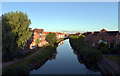
There are currently over 7.5m images from over14,400 individuals and you can help contribute to the project by visiting https://www.geograph.org.uk
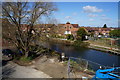
Image Map
Images are licensed for reuse under creativecommons.org/licenses/by-sa/2.0
Notes
- Clicking on the map will re-center to the selected point.
- The higher the marker number, the further away the image location is from the centre of the postcode.
Image Listing (191 Images Found)
Images are licensed for reuse under creativecommons.org/licenses/by-sa/2.0
Image
Details
Distance
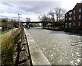
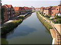
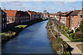
1
Beverley Beck from Hull Road Bridge, Beverley
Image: © Ian S
Taken: 27 Mar 2015
0.03 miles

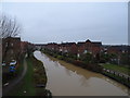
3
Beverley Beck
The beck is seen from the bridge carrying Hull Road (A1174) over it.
Image: © habiloid
Taken: 1 Aug 2020
0.04 miles
4
Beverley Beck on a Sunday morning in October
Image: © Neil Theasby
Taken: 5 Oct 2014
0.04 miles
5
Beverley Beck and the Grovehill Flyover
Image: © Andy Beecroft
Taken: 21 Mar 2008
0.04 miles
6
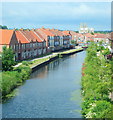
Beverley, HU17
A picture taken from the road bridge carrying the A1174 (the Hull-Beverley Road) showing houses alongside Beverley Beck, with the Minster in the distance. This canal (or beck) runs from Grovehill Lock on the River Hull into Beverley, a distance of about 0.8 miles (1.3 km). The beck was tidal until 1802 when a lock was built to maintain the canal water levels when it became necessary for the canal to travel over the top a tunnel built beneath it as a conduit for the Beverley and Barmston Drain. In 1898, a steam engine was installed that could be used to top up the water levels in the beck from the River Hull. Canal transport, even following the arrival of a local railway, meant that raw materials and finished products could be transported in and out of Beverley; a state of affairs that contributed to the development of Beverley’s prosperity. In 2005, a multi-million pound scheme began to redevelop the Beck and its surroundings. The final phase of the scheme - in 2007/8 - involved restoration of the 1953 lock gates and the pumping station, together with the construction of its associated footpaths and cycle routes.
Image: © David Hallam-Jones
Taken: 4 Jul 2013
0.04 miles
7
Beverley Beck
Canalised in the past to allow access by boat into Beverley.
View from the bridge on the A1174.
Image: © JThomas
Taken: 21 Dec 2019
0.04 miles
8
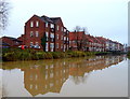
Beverley Beck
Canalised in the past to allow access by boat into Beverley.
Image: © JThomas
Taken: 21 Dec 2019
0.05 miles
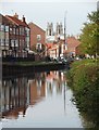
9
Beverley Beck
The A1174 runs NS along the east edge of the square over the beck where this view is from. The minster is in the adjacent square.
Image: © Stephen Horncastle
Taken: 4 Sep 2005
0.05 miles
10
Beverley Beck from Hull Road Bridge, Beverley
Image: © Ian S
Taken: 27 Mar 2015
0.05 miles