IMAGES TAKEN NEAR TO
Long Lane, BEVERLEY, HU17 0NJ
Introduction
This page details the photographs taken nearby to Long Lane, HU17 0NJ by members of the Geograph project.
The Geograph project started in 2005 with the aim of publishing, organising and preserving representative images for every square kilometre of Great Britain, Ireland and the Isle of Man.

There are currently over 7.5m images from over14,400 individuals and you can help contribute to the project by visiting https://www.geograph.org.uk
Image Map
Images are licensed for reuse under creativecommons.org/licenses/by-sa/2.0
Notes
- Clicking on the map will re-center to the selected point.
- The higher the marker number, the further away the image location is from the centre of the postcode.
Image Listing (898 Images Found)
Images are licensed for reuse under creativecommons.org/licenses/by-sa/2.0
Image
Details
Distance

3
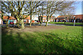
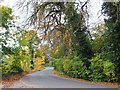
Turf Zone "MinsterAvenue"
Green on Minster Avenue, Beverley.
Image: © Ian S
Taken: 19 Feb 2023
0.04 miles
4
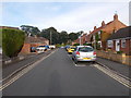
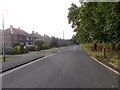
Minster Avenue - looking towards Long Lane
Image: © Betty Longbottom
Taken: 31 Jul 2015
0.04 miles
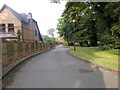
5
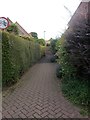
Long Lane - viewed from Old Manor Lawns
Image: © Betty Longbottom
Taken: 31 Jul 2015
0.05 miles

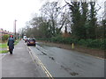
9
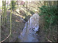
Long Lane, Beverley, Yorkshire
'It's a long lane that has no turning' and Long Lane has several of the latter on its route from Keldgate to Hull Road, Woodmansey. This stretch of the lane runs parallel with Mill Dam Drain.
Image: © Bernard Sharp
Taken: 26 Oct 2015
0.06 miles