IMAGES TAKEN NEAR TO
Grovehill Road, BEVERLEY, HU17 0JN
Introduction
This page details the photographs taken nearby to Grovehill Road, HU17 0JN by members of the Geograph project.
The Geograph project started in 2005 with the aim of publishing, organising and preserving representative images for every square kilometre of Great Britain, Ireland and the Isle of Man.

There are currently over 7.5m images from over14,400 individuals and you can help contribute to the project by visiting https://www.geograph.org.uk
Image Map
Images are licensed for reuse under creativecommons.org/licenses/by-sa/2.0
Notes
- Clicking on the map will re-center to the selected point.
- The higher the marker number, the further away the image location is from the centre of the postcode.
Image Listing (99 Images Found)
Images are licensed for reuse under creativecommons.org/licenses/by-sa/2.0
Image
Details
Distance
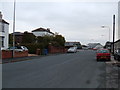
1
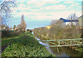
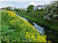
Beverley & Barmston Drain, Grovehill
A public footpath runs alongside the drain, linking Grovehill Road and Swine Moor.
Image: © Paul Harrop
Taken: 3 Dec 2007
0.09 miles
2
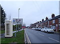
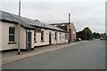
K6 telephone box on Grovehill Road, Beverley
Complex junction with the A1174 ahead.
Image: © JThomas
Taken: 21 Dec 2019
0.11 miles
3
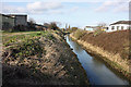
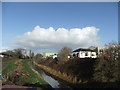
Beverley and Barmston Drain
Looking north from Grovehill Road. The west bank also carries a footpath at this point.
Image: © Peter Church
Taken: 12 Mar 2009
0.11 miles
5
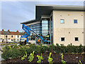
New Business Centre, Beverley
The finishing touches being put to a new business centre (or enterprise centre, depending on which report you read). At the junction of Beck View Road and Grovehill Road, the centre is being built, and part-financed, by East Riding of Yorkshire Council.
It is on a brownfield site formerly occupied by a council depot and ambulance station. The centre comprises a combination of office and light industrial units, with 14 workshops on the ground floor, and 17 offices on the first floor.
Image: © Paul Harrop
Taken: 11 Jan 2022
0.12 miles

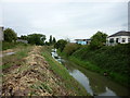
8
Beverley and Barmston Drain
The Beverley and Barmston Drainage Act was passed in 1798 to drain the marshes to the west of the river Hull. Depicted is the drain north of Grovehill Road, with Acorn Industrial Estate between the east bank and Riverview Road.
Image: © Bernard Sharp
Taken: 20 May 2016
0.12 miles
10
A walk along the River Hull #35
The Beverley and Barmston Drain.
Image: © Ian S
Taken: 6 Aug 2010
0.12 miles