IMAGES TAKEN NEAR TO
James Ingle Mews, BEVERLEY, HU17 0GR
Introduction
This page details the photographs taken nearby to James Ingle Mews, HU17 0GR by members of the Geograph project.
The Geograph project started in 2005 with the aim of publishing, organising and preserving representative images for every square kilometre of Great Britain, Ireland and the Isle of Man.

There are currently over 7.5m images from over14,400 individuals and you can help contribute to the project by visiting https://www.geograph.org.uk
Image Map
Images are licensed for reuse under creativecommons.org/licenses/by-sa/2.0
Notes
- Clicking on the map will re-center to the selected point.
- The higher the marker number, the further away the image location is from the centre of the postcode.
Image Listing (348 Images Found)
Images are licensed for reuse under creativecommons.org/licenses/by-sa/2.0
Image
Details
Distance
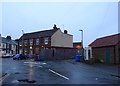
1
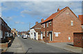
Holme Church Lane, Beverley
James Ingle Mews on the right.
Image: © Des Blenkinsopp
Taken: 4 Apr 2019
0.02 miles
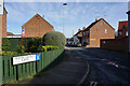
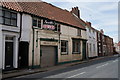
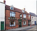
3
Former Buck Inn on Beckside, Beverley
http://www.geograph.org.uk/photo/3021627
Image: © Ian S
Taken: 31 Aug 2016
0.02 miles
4
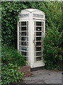
Potter Hill, Beverley
K6 telephone kiosk at Potter Hill on the southern end of St. Nicholas Road, Beverley. Hull's telephone company, now Kingston Communications, never joined the national telecommunications industry and as a result installed cream telephone boxes in the surrounding area when the rest of the country had red ones. Perhaps as a result of this statement of individuality, Hull still had a reported 239 of the iconic K series telephone kiosks operating in 2006.
Image: © Paul Glazzard
Taken: 17 Jun 2007
0.02 miles
6
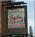
The Sign of the Buck Inn
The Buck Inn Image is situated at 25 Beckside, Beverley.
Image: © David Wright
Taken: 11 May 2008
0.02 miles
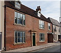
8
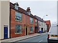
Beckside, Beverley, Yorkshire
No.25 Beckside, 18th century. A public house was first recorded here in 1727, referred to as the Buck Inn in 1759. The pub closed in 2009, when planning approval was granted to convert it and No.23 to form four dwellings. A detailed history of the building may be found here: http://www.paul-gibson.com/pubs-and-breweries/beverley-pubs-a-to-b.php Grade II Listed Building http://list.historicengland.org.uk/resultsingle.aspx?uid=1084114
Image: © Bernard Sharp
Taken: 20 Aug 2015
0.02 miles
9
The Buck Inn, Beverley
The Buck Inn is situated at 25 Beckside.
Image: © David Wright
Taken: 11 May 2008
0.03 miles
10
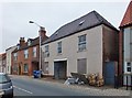
Beckside, Beverley, Yorkshire
Liliput, No.27 Beckside, 18th century. Presently being refurbished for housing purposes.
Grade II Listed Building http://list.historicengland.org.uk/resultsingle.aspx?uid=1084115
Image: © Bernard Sharp
Taken: 20 Aug 2015
0.03 miles