IMAGES TAKEN NEAR TO
Thompson Avenue, BEVERLEY, HU17 0BG
Introduction
This page details the photographs taken nearby to Thompson Avenue, HU17 0BG by members of the Geograph project.
The Geograph project started in 2005 with the aim of publishing, organising and preserving representative images for every square kilometre of Great Britain, Ireland and the Isle of Man.

There are currently over 7.5m images from over14,400 individuals and you can help contribute to the project by visiting https://www.geograph.org.uk
Image Map
Images are licensed for reuse under creativecommons.org/licenses/by-sa/2.0
Notes
- Clicking on the map will re-center to the selected point.
- The higher the marker number, the further away the image location is from the centre of the postcode.
Image Listing (278 Images Found)
Images are licensed for reuse under creativecommons.org/licenses/by-sa/2.0
Image
Details
Distance
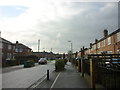
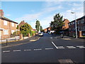
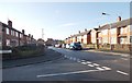
2
Riding Fields Square - Thompson Avenue
Image: © Betty Longbottom
Taken: 29 Jul 2015
0.03 miles
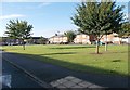
4
Riding Fields Square - Greenwood Avenue
Image: © Betty Longbottom
Taken: 29 Jul 2015
0.05 miles
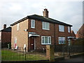
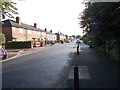
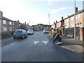
5
Hodgson Avenue - viewed from Thompson Avenue
Image: © Betty Longbottom
Taken: 29 Jul 2015
0.05 miles
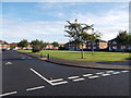
6
Thompson Avenue - Cherry Tree Lane
Image: © Betty Longbottom
Taken: 29 Jul 2015
0.05 miles
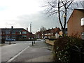
8
Towards Thompson Avennue
Looking across Cherry Tree Lane from Holderness Crescent.
Image: © DS Pugh
Taken: 2 Sep 2023
0.06 miles
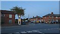
9
Cherry Tree Lane - viewed from Thompson Avenue
Image: © Betty Longbottom
Taken: 29 Jul 2015
0.06 miles
10
Hodgson Avenue - viewed from Thompson Avenue
Image: © Betty Longbottom
Taken: 29 Jul 2015
0.06 miles