IMAGES TAKEN NEAR TO
Riplingham Road, COTTINGHAM, HU16 5YR
Introduction
This page details the photographs taken nearby to Riplingham Road, HU16 5YR by members of the Geograph project.
The Geograph project started in 2005 with the aim of publishing, organising and preserving representative images for every square kilometre of Great Britain, Ireland and the Isle of Man.

There are currently over 7.5m images from over14,400 individuals and you can help contribute to the project by visiting https://www.geograph.org.uk
Image Map
Images are licensed for reuse under creativecommons.org/licenses/by-sa/2.0
Notes
- Clicking on the map will re-center to the selected point.
- The higher the marker number, the further away the image location is from the centre of the postcode.
Image Listing (8 Images Found)
Images are licensed for reuse under creativecommons.org/licenses/by-sa/2.0
Image
Details
Distance
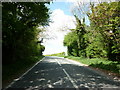
1
Riplingham Road, Raywell
Rear entrance to Braffords Hall is on the left.
Image: © Paul Harrop
Taken: 26 Feb 2008
0.03 miles
3
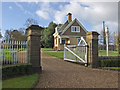
Braffords Hall entrance gate and lodge
Entrance to this large house at Raywell
Image: © Paul Harrop
Taken: 26 Feb 2008
0.14 miles
4
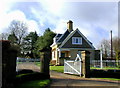
Braffords Hall Lodge
Lodge at the northern end of the driveway to Braffords Hall on the south side of Riplingham Road, west of Raywell.
Image: © Paul Glazzard
Taken: 2 Mar 2009
0.15 miles
5
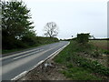
The road to Riplingham
The road to Riplingham here comes up the hill from Raywell Park and House, and Nut Wood.
Image: © Marathon
Taken: 18 Apr 2024
0.18 miles