IMAGES TAKEN NEAR TO
Newfield Lane, BROUGH, HU15 2JP
Introduction
This page details the photographs taken nearby to Newfield Lane, HU15 2JP by members of the Geograph project.
The Geograph project started in 2005 with the aim of publishing, organising and preserving representative images for every square kilometre of Great Britain, Ireland and the Isle of Man.

There are currently over 7.5m images from over14,400 individuals and you can help contribute to the project by visiting https://www.geograph.org.uk
Image Map
Images are licensed for reuse under creativecommons.org/licenses/by-sa/2.0
Notes
- Clicking on the map will re-center to the selected point.
- The higher the marker number, the further away the image location is from the centre of the postcode.
Image Listing (8 Images Found)
Images are licensed for reuse under creativecommons.org/licenses/by-sa/2.0
Image
Details
Distance
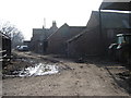
1
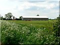
Footpath to Cave Common Farm
Cave Common Farm is in the centre of the picture.
Image: © Jonathan Thacker
Taken: 14 Aug 2016
0.02 miles
5
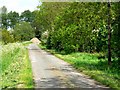
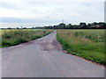
Newfield Lane
Newfield Lane leads to Cave Common Farm
Image: © Roger Gilbertson
Taken: 25 May 2006
0.14 miles
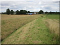
7
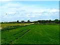
Farmland South of the A63
The lampposts line the A63
Image: © Roger Gilbertson
Taken: 25 May 2006
0.14 miles