IMAGES TAKEN NEAR TO
Beverley Road, BROUGH, HU15 2BD
Introduction
This page details the photographs taken nearby to Beverley Road, HU15 2BD by members of the Geograph project.
The Geograph project started in 2005 with the aim of publishing, organising and preserving representative images for every square kilometre of Great Britain, Ireland and the Isle of Man.

There are currently over 7.5m images from over14,400 individuals and you can help contribute to the project by visiting https://www.geograph.org.uk
Image Map
Images are licensed for reuse under creativecommons.org/licenses/by-sa/2.0
Notes
- Clicking on the map will re-center to the selected point.
- The higher the marker number, the further away the image location is from the centre of the postcode.
Image Listing (28 Images Found)
Images are licensed for reuse under creativecommons.org/licenses/by-sa/2.0
Image
Details
Distance
1
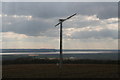
2-bladed wind turbine by Mount Airy Farm
With sweeping views across the River Humber.
Image: © Chris
Taken: 25 Mar 2015
0.01 miles
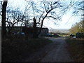
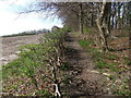
4
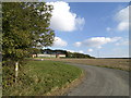
The Wolds way near to Mount Airey Farm
Image: © Andy Beecroft
Taken: 20 Oct 2007
0.02 miles
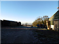
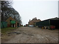
5
Mount Airy Farm
View NE from SE933311 to Mount Airy Farm.
Image: © Stephen Horncastle
Taken: 25 Nov 2006
0.03 miles
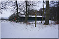
7
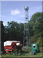
Mount Airy Farm
Telecommunications mast at Mount Airy Farm on Great Wold, on the Yorkshire Wolds Way near the parish boundary between South Cave and Ellerker.
Image: © Paul Glazzard
Taken: 30 Sep 2007
0.04 miles