IMAGES TAKEN NEAR TO
Aviation Way, BROUGH, HU15 1YJ
Introduction
This page details the photographs taken nearby to Aviation Way, HU15 1YJ by members of the Geograph project.
The Geograph project started in 2005 with the aim of publishing, organising and preserving representative images for every square kilometre of Great Britain, Ireland and the Isle of Man.

There are currently over 7.5m images from over14,400 individuals and you can help contribute to the project by visiting https://www.geograph.org.uk
Image Map
Images are licensed for reuse under creativecommons.org/licenses/by-sa/2.0
Notes
- Clicking on the map will re-center to the selected point.
- The higher the marker number, the further away the image location is from the centre of the postcode.
Image Listing (34 Images Found)
Images are licensed for reuse under creativecommons.org/licenses/by-sa/2.0
Image
Details
Distance
1
Variations on a chimney, Brough
The "shed" belongs to BAe Systems, and was built in the 1930s. The chimneys have "sprouted" in the last 10 years.
Image: © Peter Church
Taken: 12 Feb 2008
0.08 miles
2
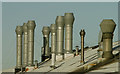
Assorted Vent Stacks
Situated on the former British Aerospace fact. Brough
Image: © Andy Beecroft
Taken: 2 Dec 2019
0.09 miles
3

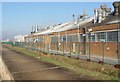
British Aerospace factory
Or at least it was the British Aerospace factory until it started to be wound down, and the buildings let to other businesses.
The sea wall was almost breached by high water levels on 5th December 2013.
Image: © Chris Morgan
Taken: 10 Mar 2015
0.10 miles
4

Trans Pennine Trail at Brough
Passing the British Aerospace factory
Image: © Graham Hogg
Taken: 10 Mar 2015
0.10 miles
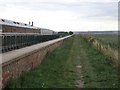
5
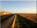
Trans Pennine Trail alongside the Flood Wall at Brough
Factory to the left, the wide and hopefully strong flood wall,the grassed Trans Pennine Trail and the reed beds to the Humber shore.
Image: © Martin Dawes
Taken: 23 Dec 2015
0.10 miles
6

Trans Pennine Trail at Brough
Passing the British Aerospace factory
Image: © Graham Hogg
Taken: 10 Mar 2015
0.12 miles
7
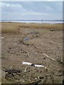
Debris on the shoreline
Stranded pieces of timber, plastic blown or washed to the shore, the odd tyre probably dumped at some time, and other debris which litter the shoreline of the Humber at Brough.
Image: © Gordon Hatton
Taken: 18 Feb 2014
0.12 miles
8
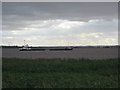
Blackboxes In The Humber
As seen from the Trans-Pennine Trail. The original photograph clearly shows the name on the hull of the ship to be "Blackboxes".
Image: © Roger Gilbertson
Taken: 9 Aug 2006
0.13 miles
9
The Trans-Pennine Trail
The trail passes the aeronautical factory of BAE Systems at Brough.
Image: © Roger Gilbertson
Taken: 9 Aug 2006
0.13 miles
10
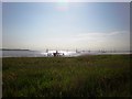
View along the Humber
The Humber estuary near Brough, taken from the Trans Pennine Trail along the foreshore, with the jetty housing navigation lights visible and a flotilla from Brough Haven in the distance.
Image: © Dr Patty McAlpin
Taken: 24 May 2009
0.13 miles