IMAGES TAKEN NEAR TO
Etherington Field, HU15 1UL
Introduction
This page details the photographs taken nearby to Etherington Field, HU15 1UL by members of the Geograph project.
The Geograph project started in 2005 with the aim of publishing, organising and preserving representative images for every square kilometre of Great Britain, Ireland and the Isle of Man.

There are currently over 7.5m images from over14,400 individuals and you can help contribute to the project by visiting https://www.geograph.org.uk
Image Map
Images are licensed for reuse under creativecommons.org/licenses/by-sa/2.0
Notes
- Clicking on the map will re-center to the selected point.
- The higher the marker number, the further away the image location is from the centre of the postcode.
Image Listing (36 Images Found)
Images are licensed for reuse under creativecommons.org/licenses/by-sa/2.0
Image
Details
Distance
2
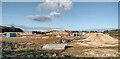
Early Stages of the latest part of a large Brough Housing Estate
This is the latest area of development on the new Brough housing estate south of the main railway track.
Image: © Andy Beecroft
Taken: 29 Sep 2022
0.07 miles
5
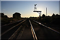
Straight line towards Brough at Welton crossing
The straight section starts at Melton and runs past Brough, Broomfleet, Staddlethorpe (Gilberdyke), Eastrington, Brind, Wressle, and on almost to Selby before there is a bend. Welton crossing gives priority to trains, so the signal is set as per the photograph unless the crossing keeper has been called and he agrees to open the gates.
Image: © Peter Church
Taken: 25 Jun 2009
0.09 miles
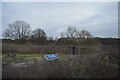
6
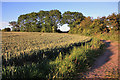
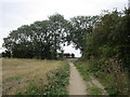
Wheatfield, and footpath to Common Lane
Image: © Peter Church
Taken: 25 Jun 2009
0.12 miles
8
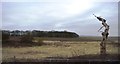
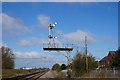
Signal at Welton Crossing
The design and position of this signal indicates that this was once a four tracked section of line.
Image: © Jonathan Thacker
Taken: 16 Aug 2014
0.12 miles
9
Approaching Common Lane
On the bridleway from Brough.
Image: © Jonathan Thacker
Taken: 16 Aug 2014
0.13 miles
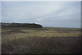
10
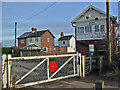
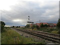
Welton Level Crossing
Looking NE from the south edge of the grid square.
Image: © Stephen Horncastle
Taken: 22 Jan 2006
0.13 miles