IMAGES TAKEN NEAR TO
Ryedale, BROUGH, HU15 1SE
Introduction
This page details the photographs taken nearby to Ryedale, HU15 1SE by members of the Geograph project.
The Geograph project started in 2005 with the aim of publishing, organising and preserving representative images for every square kilometre of Great Britain, Ireland and the Isle of Man.

There are currently over 7.5m images from over14,400 individuals and you can help contribute to the project by visiting https://www.geograph.org.uk
Image Map
Images are licensed for reuse under creativecommons.org/licenses/by-sa/2.0
Notes
- Clicking on the map will re-center to the selected point.
- The higher the marker number, the further away the image location is from the centre of the postcode.
Image Listing (5 Images Found)
Images are licensed for reuse under creativecommons.org/licenses/by-sa/2.0
Image
Details
Distance
1

The view over the River Humber from Elloughton Hill
Taken on a cold, damp January afternoon!
Image: © Andy Beecroft
Taken: 6 Jan 2007
0.02 miles
2
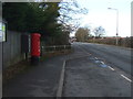
Welton Low Road, Elloughton
Showing position of Postbox No. HU15 319.
See Image] for postbox.
Image: © JThomas
Taken: 26 Jan 2018
0.05 miles
3
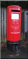
Elizabeth II postbox on Welton Low Road, Elloughton
Image: © JThomas
Taken: 26 Jan 2018
0.06 miles
4
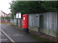
Elizabeth II postbox on Welton Low Road, Elloughton
Postbox No. HU15 319.
See Image] for postbox.
Image: © JThomas
Taken: 26 Jan 2018
0.06 miles
