IMAGES TAKEN NEAR TO
Trent Walk, BROUGH, HU15 1GF
Introduction
This page details the photographs taken nearby to Trent Walk, HU15 1GF by members of the Geograph project.
The Geograph project started in 2005 with the aim of publishing, organising and preserving representative images for every square kilometre of Great Britain, Ireland and the Isle of Man.

There are currently over 7.5m images from over14,400 individuals and you can help contribute to the project by visiting https://www.geograph.org.uk
Image Map
Images are licensed for reuse under creativecommons.org/licenses/by-sa/2.0
Notes
- Clicking on the map will re-center to the selected point.
- The higher the marker number, the further away the image location is from the centre of the postcode.
Image Listing (30 Images Found)
Images are licensed for reuse under creativecommons.org/licenses/by-sa/2.0
Image
Details
Distance
1
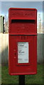
Close up, Elizabeth II postbox on Wiske Avenue, Brough
Postbox No. HU15 131.
See Image] for wider view.
Image: © JThomas
Taken: 26 Jan 2018
0.05 miles
2
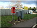
Elizabeth II postbox on Wiske Avenue, Brough
Image: © JThomas
Taken: 26 Jan 2018
0.05 miles
3
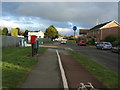
Wiske Avenue, Brough
Showing position of Postbox No. HU15 131.
See Image] for postbox.
Image: © JThomas
Taken: 26 Jan 2018
0.06 miles
4

Elloughtonthorpe Way, Brough
Part of the large housing development at the eastern end of Brough. It may even technically be part of Welton.
Image: © Paul Harrop
Taken: 5 Mar 2008
0.13 miles
5

The new Welton Primary School
On Elloughtonthorpe Way. The roof owes its purplish colour to the sedum plants which cover it. For comparison, see Image
Image: © Paul Harrop
Taken: 5 Mar 2008
0.13 miles
6
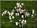
Pixie City in Moor Road
One of several large clumps of fungi on the verge of Moor Road in Brough.
Image: © Andy Beecroft
Taken: 11 Oct 2018
0.14 miles
7

Roundabout, Brough
Silver birches adorn this roundabout on the Welton Road, also seen in Image
Image: © Derek Harper
Taken: 5 Jan 2014
0.15 miles
8

New Housing Development
Looking NW from near Welton Level Crossing to the new housing development.
Image: © Stephen Horncastle
Taken: 22 Jan 2006
0.16 miles

10

Welton Road, Brough
A roundabout where the road to Welton meets Myrtle Way and Moor Road; see also Image
Image: © Derek Harper
Taken: 5 Jan 2014
0.17 miles