IMAGES TAKEN NEAR TO
Kingsley Close, BROUGH, HU15 1EJ
Introduction
This page details the photographs taken nearby to Kingsley Close, HU15 1EJ by members of the Geograph project.
The Geograph project started in 2005 with the aim of publishing, organising and preserving representative images for every square kilometre of Great Britain, Ireland and the Isle of Man.

There are currently over 7.5m images from over14,400 individuals and you can help contribute to the project by visiting https://www.geograph.org.uk
Image Map
Images are licensed for reuse under creativecommons.org/licenses/by-sa/2.0
Notes
- Clicking on the map will re-center to the selected point.
- The higher the marker number, the further away the image location is from the centre of the postcode.
Image Listing (71 Images Found)
Images are licensed for reuse under creativecommons.org/licenses/by-sa/2.0
Image
Details
Distance
2
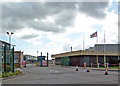
Entrance to BAe Brough Plant
This entrance is situated on Saltgrounds Road.
Image: © David Wright
Taken: 5 Apr 2008
0.05 miles

5
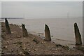
Rotting Posts on the muddy Humber Shore
The Humber Bridge can be seen in the distance.
Image: © Jennifer Petrie
Taken: 12 Apr 2022
0.08 miles
8
Skillings Lane Level Crossing, Brough
On the right of the photo is the East Brough Signal Box.
Image: © David Wright
Taken: 5 Apr 2008
0.10 miles
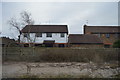
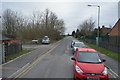
9
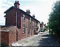
Railway Cottages, Brough
Row of houses southeast of the level crossing on Skillings Lane.
Image: © Paul Glazzard
Taken: 13 Jul 2008
0.11 miles