IMAGES TAKEN NEAR TO
Howlett Close, HESSLE, HU13 0GR
Introduction
This page details the photographs taken nearby to Howlett Close, HU13 0GR by members of the Geograph project.
The Geograph project started in 2005 with the aim of publishing, organising and preserving representative images for every square kilometre of Great Britain, Ireland and the Isle of Man.

There are currently over 7.5m images from over14,400 individuals and you can help contribute to the project by visiting https://www.geograph.org.uk
Image Map
Images are licensed for reuse under creativecommons.org/licenses/by-sa/2.0
Notes
- Clicking on the map will re-center to the selected point.
- The higher the marker number, the further away the image location is from the centre of the postcode.
Image Listing (26 Images Found)
Images are licensed for reuse under creativecommons.org/licenses/by-sa/2.0
Image
Details
Distance
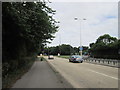
1
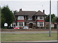
Bluebell Residential Care Home
On Boothferry Road, Hessle.
Image: © Ian S
Taken: 10 Aug 2013
0.05 miles
3
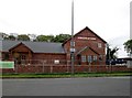
New build soon to be opened family friendly pub
Called the Wingfield Farm it is expected to open on the 6th of June 2017, creating 70 jobs, the entrance is on Boothferry Road and the exit onto the A164
Image: © Martin Dawes
Taken: 29 Apr 2017
0.06 miles
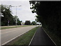
4
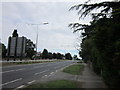
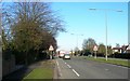
Looking southeast on the A164 near Hessle
Image: © Rod Allday
Taken: 5 Jun 2014
0.08 miles
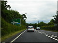
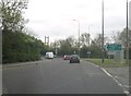
6
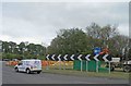
Roundabout ahead on the A15 heading for the Humber Bridge
Image: © Steve Fareham
Taken: 10 May 2013
0.12 miles
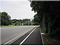
10
A15 Humber bridge approach road
The northern towers of the bridge can be seen over the trees
Image: © Martin Dawes
Taken: 29 Apr 2017
0.16 miles