IMAGES TAKEN NEAR TO
HULL, HU1 1XF
Introduction
This page details the photographs taken nearby to HU1 1XF by members of the Geograph project.
The Geograph project started in 2005 with the aim of publishing, organising and preserving representative images for every square kilometre of Great Britain, Ireland and the Isle of Man.

There are currently over 7.5m images from over14,400 individuals and you can help contribute to the project by visiting https://www.geograph.org.uk
Image Map
Images are licensed for reuse under creativecommons.org/licenses/by-sa/2.0
Notes
- Clicking on the map will re-center to the selected point.
- The higher the marker number, the further away the image location is from the centre of the postcode.
Image Listing (1880 Images Found)
Images are licensed for reuse under creativecommons.org/licenses/by-sa/2.0
Image
Details
Distance
3
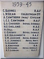
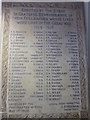
A War Memorial at the parcels office on Tower Street
Inside the parcels office is the war memorial to the lost post workers of Hull in two world wars.
Image: © Ian S
Taken: 14 Aug 2012
0.02 miles
4
A War Memorial at the parcels office on Tower Street
Inside the parcels office is the war memorial to the lost post workers of Hull in two world wars.
Image: © Ian S
Taken: 14 Aug 2012
0.02 miles
5
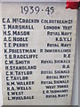
A War Memorial at the parcels office on Tower Street
Inside the parcels office is the war memorial to the lost post workers of Hull in two world wars.
Image: © Ian S
Taken: 14 Aug 2012
0.02 miles
6

A War Memorial at the parcels office in Tower Street
Inside the parcels office is the war memorial to the lost post workers of Hull in two world wars.
Image: © Ian S
Taken: 14 Aug 2012
0.02 miles
7
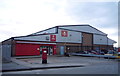
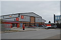
Royal Mail Delivery Office, Hull
Showing position of Postbox No. HU9 307.
See Image] for postbox.
Image: © JThomas
Taken: 7 Dec 2019
0.02 miles
8
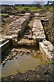
The Citadel, Kingston upon Hull
The Citadel was a massive triangular fort, constructed 1681-85, on the east bank of the river Hull in Drypool at the confluence with the Humber estuary. The fortress ceased to be used for military purposes in 1848 and was demolished in 1864. An archaeological survey of the site was undertaken in 1987-88. Today, the site is occupied by the Citadel Trading Park and Victoria Dock Village.
Illustrated is the entrance passage to the northernmost sally port, a gateway or opening to allow a sudden rushing forth of troops from a fortified place to attack besiegers.
Image: © Bernard Sharp
Taken: 26 Aug 1988
0.02 miles
9
Post box, St. Peter Street, Hull
Image: © habiloid
Taken: 26 Feb 2022
0.03 miles
10
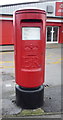
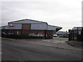
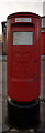
Elizabeth II postbox on Tower Street, Hull
Image: © JThomas
Taken: 7 Dec 2019
0.03 miles