IMAGES TAKEN NEAR TO
Tansterne Road, HULL, HU11 4RD
Introduction
This page details the photographs taken nearby to Tansterne Road, HU11 4RD by members of the Geograph project.
The Geograph project started in 2005 with the aim of publishing, organising and preserving representative images for every square kilometre of Great Britain, Ireland and the Isle of Man.

There are currently over 7.5m images from over14,400 individuals and you can help contribute to the project by visiting https://www.geograph.org.uk
Image Map
Images are licensed for reuse under creativecommons.org/licenses/by-sa/2.0
Notes
- Clicking on the map will re-center to the selected point.
- The higher the marker number, the further away the image location is from the centre of the postcode.
Image Listing (13 Images Found)
Images are licensed for reuse under creativecommons.org/licenses/by-sa/2.0
Image
Details
Distance
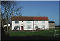
1
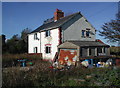
Tansterne
Two semi-detached cottages on Tansterne Lane - 'Tansterne House' in the foreground with 'Tansterne Cottage' beyond, sandwiched between Moat Farm and Tansterne Grange. These cottages, the two farms and a small house with kennels a little way down the lane to the south are the only properties in the tiny hamlet of Tansterne.
Image: © Paul Glazzard
Taken: 29 Oct 2007
0.01 miles
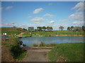
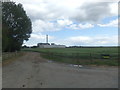
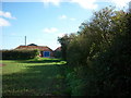
4
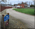
Tansterne Grange
Entrance to farm and fishing lakes on Tansterne Lane
Image: © Paul Harrop
Taken: 14 Apr 2016
0.05 miles
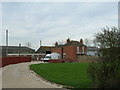
5
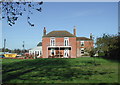
Tansterne Grange
The farmhouse at Tansterne Grange, looking north-northwest from the public footpath between Tansterne Lane and Etherdwick.
Image: © Paul Glazzard
Taken: 29 Oct 2007
0.08 miles
6
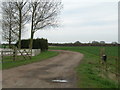
Track near Tansterne Grange (Public footpath)
Image: © JThomas
Taken: 6 Apr 2010
0.08 miles
7
Moat Farm, Tansterne
Moat Farm gets its name from a large moated enclosure west of the farmhouse on the other side of Tansterne Lane, which is thought to be the site of an old manor house. The moat itself is overgrown with trees and bushes.
Image: © Paul Glazzard
Taken: 29 Oct 2007
0.10 miles
8
Coming out at Moat Farm
This is not a Public Right of Way and should not be walked.
Image: © Ian S
Taken: 7 Oct 2010
0.11 miles
9
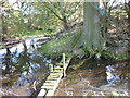
A bridge across the moat
Please note that this is not a Public Right of Way and should not be walked.
Image: © Ian S
Taken: 7 Oct 2010
0.17 miles