IMAGES TAKEN NEAR TO
Tindill Place, ISLE OF BENBECULA, HS7 5LE
Introduction
This page details the photographs taken nearby to Tindill Place, HS7 5LE by members of the Geograph project.
The Geograph project started in 2005 with the aim of publishing, organising and preserving representative images for every square kilometre of Great Britain, Ireland and the Isle of Man.

There are currently over 7.5m images from over14,400 individuals and you can help contribute to the project by visiting https://www.geograph.org.uk
Image Map
Images are licensed for reuse under creativecommons.org/licenses/by-sa/2.0
Notes
- Clicking on the map will re-center to the selected point.
- The higher the marker number, the further away the image location is from the centre of the postcode.
Image Listing (15 Images Found)
Images are licensed for reuse under creativecommons.org/licenses/by-sa/2.0
Image
Details
Distance
2
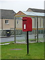
Balivanich: postbox № HS7 47, Columba Place
This postbox is emptied at 1:45pm on weekdays and at 9:30am on Saturdays.
Image: © Chris Downer
Taken: 13 Aug 2012
0.09 miles
3
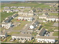
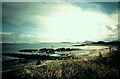
Baile a' Mhanaich from the air
Coming in to land at Benbecula Airport, on the 14.55 flight from Barra, over the housing-complex built for the armed forces at Balivanich - the school is at the top right of the picture.
Image: © Barbara Carr
Taken: 8 Jun 2009
0.10 miles
4
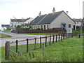
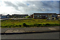
Housing Estate, Balivanich
Baile Mhanaich, the largest settlement on Benbecula - with a large military presence.
http://www.isle-of-benbecula.co.uk/
Image: © Colin Smith
Taken: 20 Jul 2011
0.12 miles
5
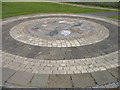
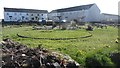
Artwork in Baile a' Mhanaich (Balavanich)
An attractive mosaic in a small park near the school in Baile a' Mhanaich.
This is not, however, one of the 'Roadends' sculptures (as I first thought it might be). That is in the grounds of the adjacent school. I now think that I did see the sculpture from a distance without realising that that was 'it'. In these enlightened times, lone males entering school grounds are regarded with extreme suspicion: if they have a camera then that is almost a confession of guilt. What nonsense! But it is, perhaps, a pity that those who located these 'Roadends' sculptures did not have regard to this issue.
There are many anglicised versions of the name Baile a' Mhanaich, including Balivanich, Ballivanich, and Bailivanish (the former name of the RAF airfield here). My 'Balavanich' comes from the 'Roadends' plaque in Image, which I assumed to be reasonably authoritative. I have been told that 'Balavanich' is a good indication to an English speaker of the pronunciation of Baile a' Mhanaich, and so I have used that version here.
Image: © David Purchase
Taken: 10 Jun 2010
0.12 miles
6
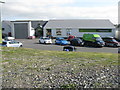
MacLennans at Baile a' Mhanaich/Balivanich
A well-stocked store in Benbecula.
Image: © M J Richardson
Taken: 2 Jun 2016
0.13 miles
7
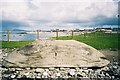
Balivanich
Sculpture entitled 'Stones Swim to Islands' in foreground, located in Balivanich school grounds, looking east along B892 to Balivanich.
Image: © Catherine Morgan
Taken: 21 May 2005
0.14 miles
8
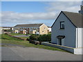
Houses at Baile a' Mhanaich/Balivanich
On the western edge of the village.
Image: © M J Richardson
Taken: 2 Jun 2016
0.15 miles