IMAGES TAKEN NEAR TO
West Tarbert, ISLE OF HARRIS, HS3 3BG
Introduction
This page details the photographs taken nearby to HS3 3BG by members of the Geograph project.
The Geograph project started in 2005 with the aim of publishing, organising and preserving representative images for every square kilometre of Great Britain, Ireland and the Isle of Man.

There are currently over 7.5m images from over14,400 individuals and you can help contribute to the project by visiting https://www.geograph.org.uk
Image Map
Images are licensed for reuse under creativecommons.org/licenses/by-sa/2.0
Notes
- Clicking on the map will re-center to the selected point.
- The higher the marker number, the further away the image location is from the centre of the postcode.
Image Listing (36 Images Found)
Images are licensed for reuse under creativecommons.org/licenses/by-sa/2.0
Image
Details
Distance
1
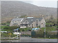
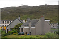
Houses at Taobh Siar
On the way north leaving Tarbert/An Tairbeart.
Image: © M J Richardson
Taken: 15 May 2013
0.01 miles
2
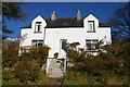
Muirneag
A traditional villa on the West Side (Taobh a' Siar) of Tarbert. Unusually for a Harris home, the house is named after a mountain in distant Lewis Image, because it was built by a Lewisman in the first decade of the 20th century.
Image: © Tiger
Taken: 19 Oct 2012
0.02 miles
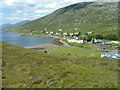
3
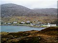
West Loch Tarbert
The quieter end of the village
Image: © Alan Reid
Taken: 20 Feb 2007
0.03 miles
6
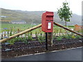
Tarbert: postbox № HS3 117
The most westerly of Tarbert's three postboxes, this one stands on a slightly shorter than usual metal pole and is emptied at 9am on weekdays and Saturdays.
Image: © Chris Downer
Taken: 17 Aug 2012
0.07 miles
7
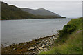
Loch a' Siar, Tarbert
Beinn Dubh in the distance.
Image: © Mike Pennington
Taken: 28 Jul 2011
0.08 miles
8
Walkway in West Tarbert
Looking towards the old pier on Loch a' Siar.
Image: © Dave Fergusson
Taken: 5 Jul 2009
0.08 miles
9
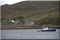
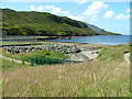
Boat in Loch a' Siar, Tarbert
With Old Pier Road in the background.
Image: © Mike Pennington
Taken: 28 Jul 2011
0.11 miles
10
Moorland above Tarbert
Looking towards Loch a Siar and the football pitch beside the junior secondary school.
The cream-coloured concrete carbuncle is the Old Hostel. This was once used to house the school kids that couldn't get home every night from classes -in the days when there were poor roads and no public transport. The Hostel is now the hub for community-related organisations including the Council, Harris Voluntary Services, North Harris Trust and the dentist and school canteen.
It is scheduled to be demolished in the near future following a major redevelopment of Sir E Scott school.
Image: © Dave Fergusson
Taken: 5 Jul 2009
0.13 miles