IMAGES TAKEN NEAR TO
Marig, ISLE OF HARRIS, HS3 3AG
Introduction
This page details the photographs taken nearby to HS3 3AG by members of the Geograph project.
The Geograph project started in 2005 with the aim of publishing, organising and preserving representative images for every square kilometre of Great Britain, Ireland and the Isle of Man.

There are currently over 7.5m images from over14,400 individuals and you can help contribute to the project by visiting https://www.geograph.org.uk
Image Map
Images are licensed for reuse under creativecommons.org/licenses/by-sa/2.0
Notes
- Clicking on the map will re-center to the selected point.
- The higher the marker number, the further away the image location is from the centre of the postcode.
Image Listing (11 Images Found)
Images are licensed for reuse under creativecommons.org/licenses/by-sa/2.0
Image
Details
Distance
1
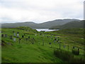
Graveyard at Maraig
Graveyard at Maraig
Image: © Graham Maxwell
Taken: 10 Aug 2006
0.09 miles
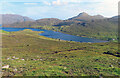
2
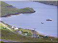
Maraig
Crofts scattered along the lochside road at the west end of Loch Maraig. A couple of fishing boats are at anchor in the sheltered bay off Loch Seaforth.
Image: © Colin Smith
Taken: 23 Jul 2011
0.12 miles
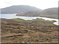
3
Loch M?raig
View of Loch Màraig from the A859 with power lines passing through.
Image: © Mat Tuck
Taken: 27 Aug 2013
0.14 miles
4
Loch M?raig
With the road to Reinigeadal on the opposite shore.
Image: © Dave Fergusson
Taken: 29 Sep 2007
0.14 miles
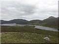
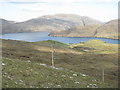
5
Loch Màraig
Loch Màraig is an arm of Loch Seaforth, a sea-loch that extends deep into the land between Lewis and Harris.
Image: © Anne Burgess
Taken: 11 Aug 2023
0.17 miles
6
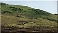
Lazy beds at Maraig
Ridges formed by hand cultivation. https://en.wikipedia.org/wiki/Lazy_bed
Image: © Sandy Gerrard
Taken: 5 Sep 2014
0.19 miles
7
Loch M?raig
An inlet from Loch Siophort/Loch Seaforth.
Image: © M J Richardson
Taken: 27 May 2016
0.19 miles
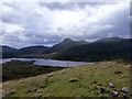
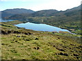
8
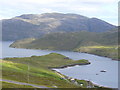
Loch Maraig
Side loch and village of the same name on the western shore of Loch Seaforth / Loch Shiphoirt. The mountain on the skyline is Caiteseal (449m), on the eastern shore of Loch Seaforth.
Image: © Colin Smith
Taken: 23 Jul 2011
0.20 miles
9
M?raig from the road to Tarbert/An Tairbeart
Looking southeast from a layby on the A859 to Rubha Eilean Anabaich and Loch Seaforth/Loch Sìophort.
Image: © M J Richardson
Taken: 15 May 2013
0.22 miles