IMAGES TAKEN NEAR TO
Cleascro Road, ISLE OF LEWIS, HS2 9PB
Introduction
This page details the photographs taken nearby to Cleascro Road, HS2 9PB by members of the Geograph project.
The Geograph project started in 2005 with the aim of publishing, organising and preserving representative images for every square kilometre of Great Britain, Ireland and the Isle of Man.

There are currently over 7.5m images from over14,400 individuals and you can help contribute to the project by visiting https://www.geograph.org.uk
Image Map
Images are licensed for reuse under creativecommons.org/licenses/by-sa/2.0
Notes
- Clicking on the map will re-center to the selected point.
- The higher the marker number, the further away the image location is from the centre of the postcode.
Image Listing (6 Images Found)
Images are licensed for reuse under creativecommons.org/licenses/by-sa/2.0
Image
Details
Distance
2
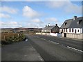
Cameron Terrace
Liurbost, on the main road towards Harris just before the turn off for Acha Mòr and West Lewis.
Image: © Richard Webb
Taken: 8 Apr 2009
0.09 miles
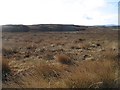
3
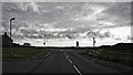
Road to Harris, seen from A858
The A859 towards Tarbert in Harris can be glimpsed here, seen from the A858 road to west Lewis from Cameron Terrace.
Image: © James Allan
Taken: 27 May 2013
0.10 miles
4
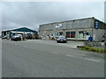
Lochs Services
This garage serves the area know as Lochs, South west of Stornoway.
Image: © Dave Fergusson
Taken: 10 Jul 2006
0.12 miles
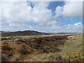
5
Liurbost Community Woodland
Newly planted woodland opposite Cameron Terrace.
Image: © Richard Webb
Taken: 8 Apr 2009
0.12 miles
6
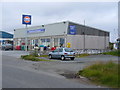
Campbell's Lochs Services Ltd
Filling station and village shop at Liurbost, on the main road about 4 miles south of Stornoway. A hairdresser (to left) shares this building and the village's recycling boxes are also located at this site.
At the rear of the services is the Lochs Bus Depot.
Image: © Colin Smith
Taken: 30 Jul 2011
0.21 miles