IMAGES TAKEN NEAR TO
Valasay, ISLE OF LEWIS, HS2 9NB
Introduction
This page details the photographs taken nearby to HS2 9NB by members of the Geograph project.
The Geograph project started in 2005 with the aim of publishing, organising and preserving representative images for every square kilometre of Great Britain, Ireland and the Isle of Man.

There are currently over 7.5m images from over14,400 individuals and you can help contribute to the project by visiting https://www.geograph.org.uk
Image Map
Images are licensed for reuse under creativecommons.org/licenses/by-sa/2.0
Notes
- Clicking on the map will re-center to the selected point.
- The higher the marker number, the further away the image location is from the centre of the postcode.
Image Listing (15 Images Found)
Images are licensed for reuse under creativecommons.org/licenses/by-sa/2.0
Image
Details
Distance
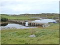
1
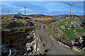
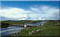
Bridge on the road to Bhalasaigh
The public road ends at Bhalasaigh a short distance after this bridge across an inlet of the sea. The next inlet is crossed by a footbridge.
Image: © Julian Paren
Taken: Unknown
0.04 miles
2
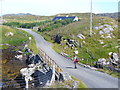
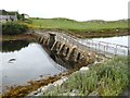
Valasay Bridge
Carrying the single track road across an outlet of the tidal lagoon, Tob Bhalasaigh on Great Bernera / Bearnaraigh.
http://www.uigandbernera.com/
Image: © Colin Smith
Taken: 27 Jul 2011
0.06 miles
3
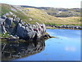
Shoreline at Tob Bhalasaigh
Rocks and heather at the edge of the tidal lagoon in Valasay.
http://www.uigandbernera.com/
Image: © Colin Smith
Taken: 27 Jul 2011
0.08 miles
4
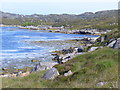
Tob Bhalasaigh
Tidal lagoon with a mix of rare seaweeds on Great Bernera / Bearnaraigh.
http://www.uigandbernera.com/
Image: © Colin Smith
Taken: 27 Jul 2011
0.09 miles
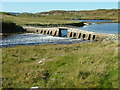
6
The Valasay/Bhalasaigh footbridge
Footbridge over the narrows at the mouth of the Tób Bhalasaigh, a very long enclosed arm of the sea. The bridge was built in 1898 to connect the houses on the west bank with the rest of Great Bernera.
Image: © Oliver Dixon
Taken: 3 Sep 2018
0.14 miles
7
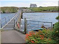
Bridge at Bhalasaigh
Looking back to the road end on the main island of Great Bernera.
Image: © Lis Burke
Taken: 1 Sep 2011
0.15 miles
8
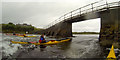
Playing in the tidal rapid at Bhalasaigh
We'd earlier paddled up into Tob Bhalasaigh with the end of the rising tide, then up towards its northern end to await the ebb gaining a bit of speed. On our return to Bhalasaigh, our timing proved excellent as there was a lot of water emptying out of the loch at some speed under the bridge. "High crossing" is a game usually played by white water kayakers, and not in the normal "remit" of sea kayakers, as the sea doesn't often cooperate in this way ! However we spent a good hour playing in this tidal rapid as the level changed until tempus fugit and we had to be elsewhere...
Image: © Andy Waddington
Taken: 16 Jul 2014
0.15 miles
9
The Valasay/Bhalasaigh footbridge
Footbridge over the narrows at the mouth of the Tób Bhalasaigh, a very long enclosed arm of the sea. The bridge was built in 1898 to connect the houses on the west bank with the rest of Great Bernera.
Image: © Oliver Dixon
Taken: 3 Sep 2018
0.15 miles
10
Footbridge at Bhalasaigh
A footpath goes north from here to the settlement of Tobson.
Image: © Dave Fergusson
Taken: 30 Sep 2007
0.15 miles