IMAGES TAKEN NEAR TO
Leurbost, ISLE OF LEWIS, HS2 9JP
Introduction
This page details the photographs taken nearby to HS2 9JP by members of the Geograph project.
The Geograph project started in 2005 with the aim of publishing, organising and preserving representative images for every square kilometre of Great Britain, Ireland and the Isle of Man.

There are currently over 7.5m images from over14,400 individuals and you can help contribute to the project by visiting https://www.geograph.org.uk
Image Map
Images are licensed for reuse under creativecommons.org/licenses/by-sa/2.0
Notes
- Clicking on the map will re-center to the selected point.
- The higher the marker number, the further away the image location is from the centre of the postcode.
Image Listing (3 Images Found)
Images are licensed for reuse under creativecommons.org/licenses/by-sa/2.0
Image
Details
Distance
1
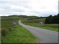
Leaving Liurbost
Flowers planted below the derestriction signs as the A859 leaves Liurbost heading south.
Image: © John Allan
Taken: 18 Jul 2006
0.11 miles
2
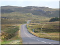
Leurbost: the A859 heads south
Leaving the village on the A859 as it heads towards Balallan and Harris. Across the road, we can see the backs of the 3-2-1 countdown markers to the 30mph speed limit in the village.
Image: © Chris Downer
Taken: 16 Aug 2012
0.14 miles
3
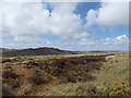
Road to Harris, seen from A858
The A859 towards Tarbert in Harris can be glimpsed here, seen from the A858 road to west Lewis from Cameron Terrace.
Image: © James Allan
Taken: 27 May 2013
0.19 miles