IMAGES TAKEN NEAR TO
Upper Shader, ISLE OF LEWIS, HS2 0RQ
Introduction
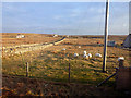
This page details the photographs taken nearby to HS2 0RQ by members of the Geograph project.
The Geograph project started in 2005 with the aim of publishing, organising and preserving representative images for every square kilometre of Great Britain, Ireland and the Isle of Man.

There are currently over 7.5m images from over14,400 individuals and you can help contribute to the project by visiting https://www.geograph.org.uk
Image Map
Images are licensed for reuse under creativecommons.org/licenses/by-sa/2.0
Notes
- Clicking on the map will re-center to the selected point.
- The higher the marker number, the further away the image location is from the centre of the postcode.
Image Listing (3 Images Found)
Images are licensed for reuse under creativecommons.org/licenses/by-sa/2.0
Image
Details
Distance
2
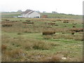
House at Siadar
It appears to be relatively recent, but is on Google Earth 2009 imagery.
Image: © M J Richardson
Taken: 13 May 2013
0.19 miles
3
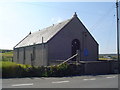
Siadar Meeting House
A very small Church of Scotland meeting house in the village of Siadar.
Image: © Donald Lawson
Taken: 22 Jul 2006
0.22 miles