IMAGES TAKEN NEAR TO
New Road, ISLE OF LEWIS, HS2 0RJ
Introduction
This page details the photographs taken nearby to New Road, HS2 0RJ by members of the Geograph project.
The Geograph project started in 2005 with the aim of publishing, organising and preserving representative images for every square kilometre of Great Britain, Ireland and the Isle of Man.

There are currently over 7.5m images from over14,400 individuals and you can help contribute to the project by visiting https://www.geograph.org.uk
Image Map (Loading...)


Getting Data...Please wait
Leaflet Map data © OpenStreetMap
Images are licensed for reuse under creativecommons.org/licenses/by-sa/2.0
Notes
- Clicking on the map will re-center to the selected point.
- The higher the marker number, the further away the image location is from the centre of the postcode.
Image Listing (5 Images Found)
Images are licensed for reuse under creativecommons.org/licenses/by-sa/2.0
Image
Details
Distance
2
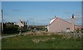
Siadar
Cottages in the village of Siadar (Shader). The nearest one has evidently been extended at some time - the roof on the right has a very different pitch from the 'normal' one on the left.
Image: © Anne Burgess
Taken: 2 Jun 2009
0.11 miles
3
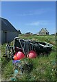
Fishing boat, Shader/Siadar, Isle of Lewis
I was told by the boat's owner that it was last used for lobster fishing about ten years before this photo was taken.
Image: © Claire Pegrum
Taken: 30 May 2018
0.12 miles
5
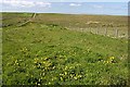
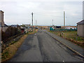
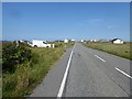
Track to the Machair
The track on the left gives access from the east end of Siadar to the machair, eventually linking with Image
Image: © Anne Burgess
Taken: 2 Jun 2009
0.23 miles