IMAGES TAKEN NEAR TO
Lower Bayble, ISLE OF LEWIS, HS2 0QE
Introduction
This page details the photographs taken nearby to HS2 0QE by members of the Geograph project.
The Geograph project started in 2005 with the aim of publishing, organising and preserving representative images for every square kilometre of Great Britain, Ireland and the Isle of Man.

There are currently over 7.5m images from over14,400 individuals and you can help contribute to the project by visiting https://www.geograph.org.uk
Image Map
Images are licensed for reuse under creativecommons.org/licenses/by-sa/2.0
Notes
- Clicking on the map will re-center to the selected point.
- The higher the marker number, the further away the image location is from the centre of the postcode.
Image Listing (3 Images Found)
Images are licensed for reuse under creativecommons.org/licenses/by-sa/2.0
Image
Details
Distance
2
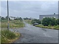
Ruined house
This house sits at the south-western edge of the village of Pabail Iarach.
Image: © Eileen Henderson
Taken: 29 Jun 2007
0.06 miles
3
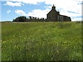
Pabail Iarach (Lower Bayble)
The village of Pabail Iarach stretches out along the road which curves round Bagh Phabail (Bayble Bay), about 50m above the bay.
Image: © Eileen Henderson
Taken: 29 Jun 2007
0.11 miles