IMAGES TAKEN NEAR TO
Camach Park, ISLE OF LEWIS, HS2 0NR
Introduction
This page details the photographs taken nearby to Camach Park, HS2 0NR by members of the Geograph project.
The Geograph project started in 2005 with the aim of publishing, organising and preserving representative images for every square kilometre of Great Britain, Ireland and the Isle of Man.

There are currently over 7.5m images from over14,400 individuals and you can help contribute to the project by visiting https://www.geograph.org.uk
Image Map (Loading...)


Getting Data...Please wait
Leaflet Map data © OpenStreetMap
Images are licensed for reuse under creativecommons.org/licenses/by-sa/2.0
Notes
- Clicking on the map will re-center to the selected point.
- The higher the marker number, the further away the image location is from the centre of the postcode.
Image Listing (10 Images Found)
Images are licensed for reuse under creativecommons.org/licenses/by-sa/2.0
Image
Details
Distance
1
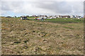
Cnoc a' Runaire
The map names this part of Tolastadh bho Tuath as Cnoc a' Runaire, which appears to mean 'the secretary's hillock'.
Image: © Anne Burgess
Taken: 14 May 2011
0.04 miles
2
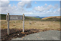
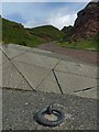
Tolsta Head Walk
A series of signposts leads to a small gravelled car park, and this sign indicates that the walk to the headland, which is about 2 kilometres away, starts here. However I saw no indication of which way to go, and there's nothing that looks like a path as far as I could see.
Image: © Anne Burgess
Taken: 14 May 2011
0.17 miles
3

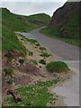
Old Landslide?
This curious piece of topography beside the track down to the beach at Tolastadh bho Tuath caught my eye. I think it may be the remains of an old landslide, during which the land on the right slipped down towards the sea and rotated outwards, leaving a gap to landward. The grassy surfaces of both parts of it are criss-crossed by solifluction terraces, created by the effects of repeated freezing and thawing.
Image] is the other side of the possible landslide from further down the track.
Image: © Anne Burgess
Taken: 14 May 2011
0.17 miles
4
Access to Tr?igh Ghioradail, Isle of Lewis
Looking towards the Image
Image: © Claire Pegrum
Taken: 13 Jun 2017
0.20 miles
5
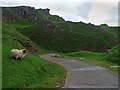
The Last House
In the foreground is part of the Tolsta Head Walk car park. The house is the last one before the open moorland which stretches to the cliffs.
Image: © Anne Burgess
Taken: 14 May 2011
0.21 miles
6
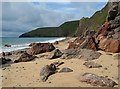
Tr?igh Ghioradail, Isle of Lewis
Looking towards Tolsta Head.
Image: © Claire Pegrum
Taken: 13 Jun 2017
0.21 miles
7
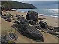
Tr?igh Ghioradail, Isle of Lewis
Looking towards Gob Girdabirie.
Image: © Claire Pegrum
Taken: 13 Jun 2017
0.22 miles
8
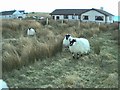
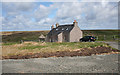
54 North Tolsta
This is taken on croft 54 of North Tolsta. It is well within NB 538 466.
Image: © Ruairidh Moir
Taken: Unknown
0.23 miles
9
Boat mooring above Tr?igh Ghioradail, Isle of Lewis
There are three platforms on which boats can be moored near the foot of the steep block paved access track between the car park and the beach.
Image: © Claire Pegrum
Taken: 13 Jun 2017
0.23 miles
10
Access to Tr?igh Ghioradail, Isle of Lewis
The Image can be seen beyond the strip of sand.
Image: © Claire Pegrum
Taken: 13 Jun 2017
0.24 miles