IMAGES TAKEN NEAR TO
Upton Bishop, ROSS-ON-WYE, HR9 7UA
Introduction
This page details the photographs taken nearby to HR9 7UA by members of the Geograph project.
The Geograph project started in 2005 with the aim of publishing, organising and preserving representative images for every square kilometre of Great Britain, Ireland and the Isle of Man.

There are currently over 7.5m images from over14,400 individuals and you can help contribute to the project by visiting https://www.geograph.org.uk
Image Map (Loading...)


Getting Data...Please wait
Leaflet Map data © OpenStreetMap
Images are licensed for reuse under creativecommons.org/licenses/by-sa/2.0
Notes
- Clicking on the map will re-center to the selected point.
- The higher the marker number, the further away the image location is from the centre of the postcode.
Image Listing (15 Images Found)
Images are licensed for reuse under creativecommons.org/licenses/by-sa/2.0
Image
Details
Distance
1

Angelica plant
This huge specimen was over 6' tall
Image: © Pauline E
Taken: 26 May 2007
0.03 miles
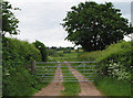
3
Sticking to the edge
The footpath officially crosses the planted field but we decided to stick to the boundary today.
Image: © Pauline E
Taken: 22 Feb 2011
0.06 miles
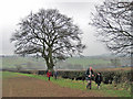
4
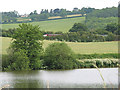
View south of Crow Hill, Upton Bishop
An early spring view towards May Hill in the distance, as well as the Hartleton Lakes and the M50 visible in the valley left.
Image: © Jonathan Billinger
Taken: 23 Mar 2007
0.06 miles
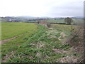
5
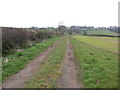
Farm track and footpath to Felhampton
The Linton-Upton ridge is within the square up ahead.
Image: © Jonathan Billinger
Taken: 23 Mar 2007
0.10 miles
6

Approaching Crow Hill from the south
The B4224 runs from Mitcheldean to Hereford.
Image: © Pauline E
Taken: 20 Apr 2009
0.12 miles
8
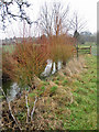
Splash of colour
Looks like a type of dogwood by the small pond beside the footpath to Felhampton.
Image: © Pauline E
Taken: 22 Feb 2011
0.12 miles
9
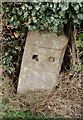
Old Milestone by the B4224, south of Crow Hill
Stone post (plate lost) by the B4224, in parish of UPTON BISHOP (District), South of Crow Hill, just South of field entrance and village sign, on West side of road. Erected by the Hereford turnpike trust in the 19th century.
Inscription once read:-
(TO)
(HEREFORD)
(13)
(MILES)
Carved benchmark front middle bottom.
Herefordshire SMR listed. SMR Number: 56478
https://www.heritagegateway.org.uk/Gateway/Results_Single.aspx?uid=MHE28335&resourceID=101
Milestone Society National ID: HF_HFGL13.
Image: © M Faherty
Taken: 12 Apr 2010
0.13 miles
10
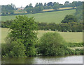
View across Hartleton lake. M50 traffic trundling through.
Image: © Pauline E
Taken: 13 Jun 2007
0.15 miles