IMAGES TAKEN NEAR TO
Hom Green, ROSS-ON-WYE, HR9 7TG
Introduction
This page details the photographs taken nearby to HR9 7TG by members of the Geograph project.
The Geograph project started in 2005 with the aim of publishing, organising and preserving representative images for every square kilometre of Great Britain, Ireland and the Isle of Man.

There are currently over 7.5m images from over14,400 individuals and you can help contribute to the project by visiting https://www.geograph.org.uk
Image Map (Loading...)


Getting Data...Please wait
Leaflet Map data © OpenStreetMap
Images are licensed for reuse under creativecommons.org/licenses/by-sa/2.0
Notes
- Clicking on the map will re-center to the selected point.
- The higher the marker number, the further away the image location is from the centre of the postcode.
Image Listing (29 Images Found)
Images are licensed for reuse under creativecommons.org/licenses/by-sa/2.0
Image
Details
Distance
1
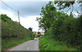
Lane in Hom Green
To Old Hill Farm and Ball's Farm.
Image: © Pauline E
Taken: 8 Sep 2008
0.03 miles
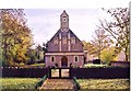
2
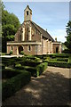
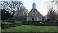
Hom Green Chapel
A former chapel now converted into a private residence.
Image: © Philip Halling
Taken: 8 Aug 2009
0.10 miles
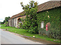
4
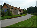
Old Barn at Hom Green
At a bend in Hom Road opposite the entrance to The Homme.
Image: © Jonathan Billinger
Taken: 18 Sep 2008
0.11 miles
5
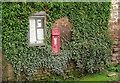
VR postbox at Hom Green
Fixed into the wall of Hom House and positioned next to the parish notice board.
Image: © Pauline E
Taken: 8 Sep 2008
0.11 miles
6
Hom House, Hom Green
Appears to be across the gridline on this scale but position shows best on the 1:25000 map. Home to a couple of camera-shy llamas.
Image: © Pauline E
Taken: 8 Sep 2008
0.11 miles
7
Hom Green Church of the Paraclete Walford
Image: © paul wood
Taken: 25 Nov 2003
0.13 miles
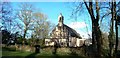
9
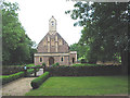
Hom Green Chapel, 2021
A private residence since at least 2007.
There is some confusion over the exact location of this building as almost identical images to this one appear as geographs in two squares. The mapping doesn't help; small scale mapping has the building well inside SO5822, but the latest large scale mapping indicates that the west wall is in fact on the 5799 line. I have decided to follow this for my image. It's impossible to verify without using a GPS and the property is private.
What is very clear, however, is that the camera position for all the images, including my own, on Archenfield Road, is well inside SO5722. Therefore all the images placed in SO5822 should really be cross-grid supplementals.
See; Image, Image, Image and Image
Image: © Jonathan Billinger
Taken: 5 Jan 2021
0.13 miles
10
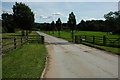
Tree-lined entrance to the Homme
View up the tree-lined entrance to the Homme, viewed from the farm towards the passing road. A footpath follows the drive.
Image: © Philip Halling
Taken: 8 Aug 2009
0.14 miles