IMAGES TAKEN NEAR TO
Rudhall Meadow, ROSS-ON-WYE, HR9 7AW
Introduction
This page details the photographs taken nearby to Rudhall Meadow, HR9 7AW by members of the Geograph project.
The Geograph project started in 2005 with the aim of publishing, organising and preserving representative images for every square kilometre of Great Britain, Ireland and the Isle of Man.

There are currently over 7.5m images from over14,400 individuals and you can help contribute to the project by visiting https://www.geograph.org.uk
Image Map (Loading...)


Getting Data...Please wait
Leaflet Map data © OpenStreetMap
Images are licensed for reuse under creativecommons.org/licenses/by-sa/2.0
Notes
- Clicking on the map will re-center to the selected point.
- The higher the marker number, the further away the image location is from the centre of the postcode.
Image Listing (424 Images Found)
Images are licensed for reuse under creativecommons.org/licenses/by-sa/2.0
Image
Details
Distance
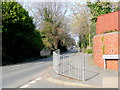
1
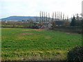
Pasture land north of the Rudhall Brook
The recently completed houses are at the end of Rudhall Meadow cul-de-sac.
Penyard in the distance, viewed from Tanyard Lane.
Image: © Jonathan Billinger
Taken: 13 Feb 2009
0.02 miles
2
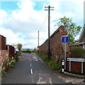
No caravans in Tanyard Lane Ross-on-Wye
The No Through Road sign has had NO CARAVANS added to the top of the sign,
but by whom? Is it an official addition, or added by a resident?
Image: © Jaggery
Taken: 30 Oct 2011
0.03 miles
3
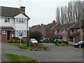
Brookmead 1
The end of a modern cul-de-sac off Over Ross Street, Ross-on-Wye.
Image: © Jonathan Billinger
Taken: 30 Dec 2008
0.04 miles
5
Tanyard Lane meets Ledbury Road, Ross-on-Wye
Looking north-east away from the town centre.
The B4234 becomes Overross Street as it progresses towards the town centre, behind the camera to the left.
Image: © Jonathan Billinger
Taken: 16 Mar 2009
0.05 miles
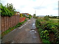
6
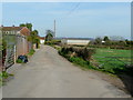
Tanyard Lane, Ross-on-Wye
Leading past the rear of the housing along Court Road to the left, with farm-land to the right deceptively close to Ross-on-Wye town centre.
Image: © Jonathan Billinger
Taken: 16 Mar 2009
0.05 miles
7
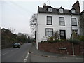
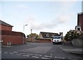
Over Ross Street, Ross-on-Wye
Looking north-east by the junction with Brookmead.
The house on the corner is a B&B.
Image: © Jonathan Billinger
Taken: 30 Dec 2008
0.05 miles
8
Brookmead 2
Looking south-east from Over Ross Street, Ross-on-Wye.
Image: © Jonathan Billinger
Taken: 30 Dec 2008
0.06 miles
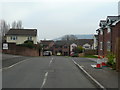
9

Ledbury Road, Ross-on-Wye
Looking along the B4234 at the junction with Brookmead.
Image: © Jonathan Billinger
Taken: 19 May 2017
0.06 miles
10
Tanyard Lane, Ross-on-Wye
Houses on the left, a field http://www.geograph.org.uk/photo/3469741 on the right and potholes in the middle.
Image: © Jaggery
Taken: 30 Oct 2011
0.07 miles