IMAGES TAKEN NEAR TO
Marstow, ROSS-ON-WYE, HR9 6HD
Introduction
This page details the photographs taken nearby to HR9 6HD by members of the Geograph project.
The Geograph project started in 2005 with the aim of publishing, organising and preserving representative images for every square kilometre of Great Britain, Ireland and the Isle of Man.

There are currently over 7.5m images from over14,400 individuals and you can help contribute to the project by visiting https://www.geograph.org.uk
Image Map (Loading...)


Getting Data...Please wait
Leaflet Map data © OpenStreetMap
Images are licensed for reuse under creativecommons.org/licenses/by-sa/2.0
Notes
- Clicking on the map will re-center to the selected point.
- The higher the marker number, the further away the image location is from the centre of the postcode.
Image Listing (5 Images Found)
Images are licensed for reuse under creativecommons.org/licenses/by-sa/2.0
Image
Details
Distance
1
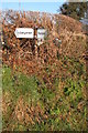
Old road sign at Stone Bridge
The old road sign is almost hidden in the hedgerow.
Image: © Philip Halling
Taken: 28 Jan 2006
0.22 miles
2
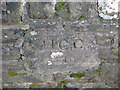
Bridge number 570
HCC - Herefordshire County Council.
Image: © Pauline E
Taken: 8 Oct 2008
0.23 miles
3
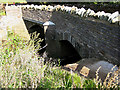
Twin arches of Stone Bridge
The far arch appears to have had some recent strengthening and there has been a lot of work on the parapet. Garren Brook passes downstream to the right on its way to join the Wye between Goodrich and Symonds Yat.
Image: © Pauline E
Taken: 8 Oct 2008
0.24 miles
4
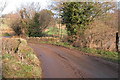
Stone Bridge over Garren Brook
This narrow bridge is on the lane between Llangarron and Ruxton.
Image: © Philip Halling
Taken: 28 Jan 2006
0.24 miles
5
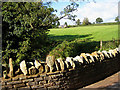
Recent repairs
Stone Bridge looks as if it has been recently repaired. The bridge has two arches supporting the road between Llangarron and Ruxton Green. On the hilltop sits Treverven.
Image: © Pauline E
Taken: 8 Oct 2008
0.25 miles