IMAGES TAKEN NEAR TO
Llangrove, ROSS-ON-WYE, HR9 6EJ
Introduction
This page details the photographs taken nearby to HR9 6EJ by members of the Geograph project.
The Geograph project started in 2005 with the aim of publishing, organising and preserving representative images for every square kilometre of Great Britain, Ireland and the Isle of Man.

There are currently over 7.5m images from over14,400 individuals and you can help contribute to the project by visiting https://www.geograph.org.uk
Image Map
Images are licensed for reuse under creativecommons.org/licenses/by-sa/2.0
Notes
- Clicking on the map will re-center to the selected point.
- The higher the marker number, the further away the image location is from the centre of the postcode.
Image Listing (9 Images Found)
Images are licensed for reuse under creativecommons.org/licenses/by-sa/2.0
Image
Details
Distance
2
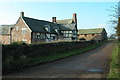
Ruxton Court
Ruxton Court at Ruxton Green is an impressive farmhouse which is currently undergoing some work.
Image: © Philip Halling
Taken: 14 Mar 2009
0.01 miles
3
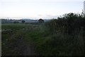
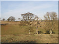
Ruxton Green
Field and roadside hedge on an Autumn evening.
Image: © Richard Webb
Taken: 20 Oct 2016
0.07 miles
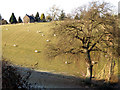
5
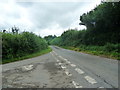
Road junction - this left turn takes you to the A4137
Image: © Ruth Sharville
Taken: 18 Aug 2012
0.15 miles
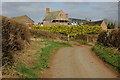
6
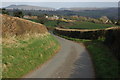
Road to Ruxton Green
The road to Ruxton Green from Llangrove. The wooded hill in the background on the left is Penyard Hill above Ross-on-Wye.
Image: © Philip Halling
Taken: 14 Mar 2009
0.17 miles
8
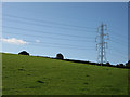
Pylon in a pasture
Between Stone Bridge and Ruxton Green.
Image: © Pauline E
Taken: 8 Oct 2008
0.21 miles
9
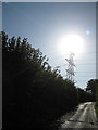
Power lines
Mighty rays or man-made lines - both are present in this grid square today.
Image: © Pauline E
Taken: 8 Oct 2008
0.25 miles