IMAGES TAKEN NEAR TO
Grange Park, ROSS-ON-WYE, HR9 6EA
Introduction
This page details the photographs taken nearby to Grange Park, HR9 6EA by members of the Geograph project.
The Geograph project started in 2005 with the aim of publishing, organising and preserving representative images for every square kilometre of Great Britain, Ireland and the Isle of Man.

There are currently over 7.5m images from over14,400 individuals and you can help contribute to the project by visiting https://www.geograph.org.uk
Image Map
Images are licensed for reuse under creativecommons.org/licenses/by-sa/2.0
Notes
- Clicking on the map will re-center to the selected point.
- The higher the marker number, the further away the image location is from the centre of the postcode.
Image Listing (175 Images Found)
Images are licensed for reuse under creativecommons.org/licenses/by-sa/2.0
Image
Details
Distance
1
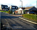
Grange Park, Whitchurch
Modern houses in the Herefordshire village.
Image: © Jaggery
Taken: 12 Feb 2012
0.00 miles
2
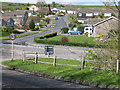
Grange Park, Whitchurch, Herefordshire
Road into an area of modern housing viewed across Old Monmouth Road.
Image: © Jaggery
Taken: 18 Aug 2019
0.02 miles
3
Grange Park, Whitchurch
Modern housing just outside the village centre.
Image: © Pauline E
Taken: 8 Apr 2008
0.03 miles
4
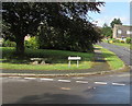
Backless bench under a tree on a corner in Whitchurch, Herefordshire
On the corner of Old Monmouth Road and Grange Park.
Image: © Jaggery
Taken: 18 Aug 2019
0.04 miles
5
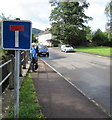
No Through Road sign, Old Monmouth Road, Whitchurch, Herefordshire
Looking to the SW along the B4164 Old Monmouth Road towards the A40 junction
where No Entry signs https://www.geograph.org.uk/photo/3808428 face vehicles travelling away from the camera.
Image: © Jaggery
Taken: 18 Aug 2019
0.05 miles
6
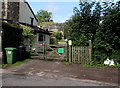
Wooden gates at the entrance to Willow End, Whitchurch, Herefordshire
The green notice https://www.geograph.org.uk/photo/6517632 on a gate shows "Willow End - 40 yards up drive. Please keep gate shut".
Image: © Jaggery
Taken: 18 Aug 2019
0.05 miles
7
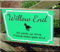
Willow End name sign, Whitchurch, Herefordshire
On a gate here https://www.geograph.org.uk/photo/6517623 in August 2019.
Image: © Jaggery
Taken: 18 Aug 2019
0.05 miles
8
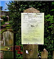
Planning notice for the Old Bakery, Whitchurch, Herefordshire
Herefordshire Council notice on display on a gatepost here https://www.geograph.org.uk/photo/6517623 on August 18th 2019.
Image: © Jaggery
Taken: 18 Aug 2019
0.05 miles
9
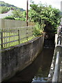
Unnamed stream in Whitchurch, Herefordshire
Below the B4164 Old Monmouth Road near the Grange Park junction.
Image: © Jaggery
Taken: 18 Aug 2019
0.06 miles
10
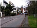
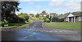
Whitchurch
Looking North East towards the central part of the village. Now bypassed by the dual carriageway A40.
Image: © Stuart Wilding
Taken: 10 Mar 2006
0.06 miles