IMAGES TAKEN NEAR TO
The Doward, Whitchurch, ROSS-ON-WYE, HR9 6DU
Introduction
This page details the photographs taken nearby to HR9 6DU by members of the Geograph project.
The Geograph project started in 2005 with the aim of publishing, organising and preserving representative images for every square kilometre of Great Britain, Ireland and the Isle of Man.

There are currently over 7.5m images from over14,400 individuals and you can help contribute to the project by visiting https://www.geograph.org.uk
Image Map
Images are licensed for reuse under creativecommons.org/licenses/by-sa/2.0
Notes
- Clicking on the map will re-center to the selected point.
- The higher the marker number, the further away the image location is from the centre of the postcode.
Image Listing (22 Images Found)
Images are licensed for reuse under creativecommons.org/licenses/by-sa/2.0
Image
Details
Distance
1
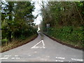
Unsuitable road for heavy goods vehicles near Sandiway Lane, Ganarew
This road is the alternative to the road to Biblins and Doward Park Camp Site at this http://www.geograph.org.uk/photo/3914102 junction.
Image: © Jaggery
Taken: 12 Feb 2012
0.07 miles
2
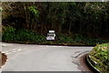
Right for Biblins and Doward Park Camp Site
Turn right here for interesting locations, or left if your preference
is a narrow road unsuitable for heavy goods vehicles. http://www.geograph.org.uk/photo/3914111
Image: © Jaggery
Taken: 12 Feb 2012
0.08 miles
3
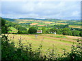
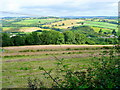
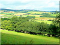
South Herefordshire farmland 2
View over Lewstone from Sawpitts Lane on the north side of Great Doward.
Image: © Jonathan Billinger
Taken: 13 Jul 2009
0.08 miles
4
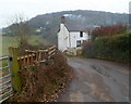
Entrance to the Kiln House, The Doward
Located in southern Herefordshire, about a kilometre north of the River Wye which in this area marks the England/Wales border.
Image: © Jaggery
Taken: 12 Feb 2012
0.09 miles
5
South Herefordshire farmland 3
Looking north from Sawpitts Lane on the Great Doward towards Llangrove.
Image: © Jonathan Billinger
Taken: 13 Jul 2009
0.09 miles
6
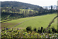
Hillside with long fence
The wooded slopes of Great Doward in the distance.
Image: © Pauline E
Taken: 8 Apr 2008
0.11 miles
7
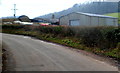
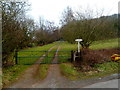
Doward Farm buildings, Little Doward
A farm in south Herefordshire near the Welsh border.
Image: © Jaggery
Taken: 12 Feb 2012
0.15 miles
8
Farmland, Crockers' Ash
Looking north from the left centre of the grid.
Image: © Stuart Wilding
Taken: 10 Mar 2006
0.17 miles
9
Little Kiln House, Little Doward
Viewed from this http://www.geograph.org.uk/photo/3853838 junction.
Image: © Jaggery
Taken: 12 Feb 2012
0.17 miles
10
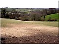
South Herefordshire farmland 1
Looking north-west from Sawpitts Lane towards the high ground of Welsh Newton Common in the distance.
Image: © Jonathan Billinger
Taken: 13 Jul 2009
0.18 miles