IMAGES TAKEN NEAR TO
Glewstone, ROSS-ON-WYE, HR9 6AN
Introduction
This page details the photographs taken nearby to HR9 6AN by members of the Geograph project.
The Geograph project started in 2005 with the aim of publishing, organising and preserving representative images for every square kilometre of Great Britain, Ireland and the Isle of Man.

There are currently over 7.5m images from over14,400 individuals and you can help contribute to the project by visiting https://www.geograph.org.uk
Image Map
Images are licensed for reuse under creativecommons.org/licenses/by-sa/2.0
Notes
- Clicking on the map will re-center to the selected point.
- The higher the marker number, the further away the image location is from the centre of the postcode.
Image Listing (8 Images Found)
Images are licensed for reuse under creativecommons.org/licenses/by-sa/2.0
Image
Details
Distance
2
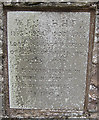
Memorial stone, Glewstone
William Frederick, 1st Baron Jackson was a politician.
Image: © Pauline E
Taken: 3 Apr 2008
0.14 miles
3
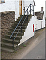
GR postbox set into a flight of steps
In an area flanked by orchards in Glewstone.
Image: © Pauline E
Taken: 3 Apr 2008
0.17 miles
4
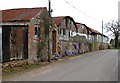
Roadside barns, Glewstone
In an area flanked by orchards.
Image: © Pauline E
Taken: 3 Apr 2008
0.17 miles
5
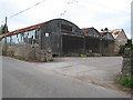
Linked barns, Glewstone
In an area with nearby orchards.
Image: © Pauline E
Taken: 3 Apr 2008
0.18 miles
6
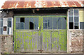
Seen better days
Doors into a series of linked barns, Glewstone, in an area flanked by orchards.
Image: © Pauline E
Taken: 3 Apr 2008
0.18 miles
7
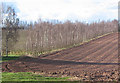
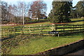
Row of birches
Possibly a windbreak, separating the orchard from the arable land.
Image: © Pauline E
Taken: 4 Mar 2008
0.23 miles
8
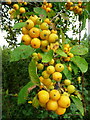
Crab apples by the roadside
These are north of the road to Glewstone, in an area of fruit growing.
These Malus species are used to pollinate varieties of cider, culinary and dessert apple.
Image: © Jonathan Billinger
Taken: 25 Sep 2008
0.24 miles