IMAGES TAKEN NEAR TO
Cherry Tree Lane, ROSS-ON-WYE, HR9 5RJ
Introduction
This page details the photographs taken nearby to Cherry Tree Lane, HR9 5RJ by members of the Geograph project.
The Geograph project started in 2005 with the aim of publishing, organising and preserving representative images for every square kilometre of Great Britain, Ireland and the Isle of Man.

There are currently over 7.5m images from over14,400 individuals and you can help contribute to the project by visiting https://www.geograph.org.uk
Image Map (Loading...)


Getting Data...Please wait
Leaflet Map data © OpenStreetMap
Images are licensed for reuse under creativecommons.org/licenses/by-sa/2.0
Notes
- Clicking on the map will re-center to the selected point.
- The higher the marker number, the further away the image location is from the centre of the postcode.
Image Listing (44 Images Found)
Images are licensed for reuse under creativecommons.org/licenses/by-sa/2.0
Image
Details
Distance
1
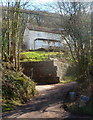
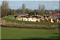
Tump House, Walford
Set back 40 metres from the B4234 on steep ground at the edge of Leys Hill.
Image: © Jaggery
Taken: 24 Feb 2012
0.10 miles
2
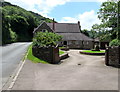
Mill House, Walford
Alongside the B4234 Walford Road. An old cider press is on the grass on the right.
Image: © Jaggery
Taken: 10 Jul 2016
0.11 miles
3
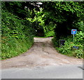
Dead-end side road in the south of Walford
The side road from the B4234 leads to houses in woodland above the east bank of the river Wye.
Image: © Jaggery
Taken: 10 Jul 2016
0.11 miles
4
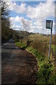
Bus stop at the southern edge of Walford
This side of the B4234 for buses to Ross-on-Wye.
Image: © Jaggery
Taken: 10 Jul 2016
0.11 miles
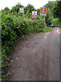
5
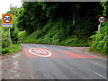
Start of the 30 zone at the southern edge of Walford
The National Speed Limit on the B4234 drops to 30mph at the southern edge of Walford, a village in southeast Herefordshire. Viewed in July 2016. A May 2009 Google Earth Street View shows 40mph speed limit signs here.
Image: © Jaggery
Taken: 10 Jul 2016
0.11 miles
6
End of the 40 zone at the SW edge of Walford
Viewed across the B4234 opposite a bus stop. The 40mph speed limit increases to the National Speed Limit ahead.
Image: © Jaggery
Taken: 24 Feb 2012
0.11 miles
7
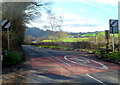
Bus stop, Walford
The Saw Mills bus stop on the B4234 near Walford, here the road is approaching Kerne Bridge. Goodrich and its church spire can be seen in the background.
Image: © Philip Halling
Taken: 30 Mar 2008
0.11 miles
8
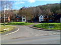
Green Colley Grove, Walford
Some maps and a few internet references show this cul-de-sac on the east side of the B4234 as
Green Colley Close, but the name signs seen here, and local estate agents' websites, disagree.
Image: © Jaggery
Taken: 24 Feb 2012
0.11 miles
9
Walford Timber Merchants, Walford
On the west side of the B4234 Walford Road.
Image: © Jaggery
Taken: 10 Jul 2016
0.11 miles
10
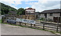
Walford Saw Mills
Walford Saw Mills viewed from the passing B4234, the tower of Walford church can be seen in the background.
Image: © Philip Halling
Taken: 30 Mar 2008
0.12 miles