IMAGES TAKEN NEAR TO
Walford, ROSS-ON-WYE, HR9 5QP
Introduction
This page details the photographs taken nearby to HR9 5QP by members of the Geograph project.
The Geograph project started in 2005 with the aim of publishing, organising and preserving representative images for every square kilometre of Great Britain, Ireland and the Isle of Man.

There are currently over 7.5m images from over14,400 individuals and you can help contribute to the project by visiting https://www.geograph.org.uk
Image Map (118 Images)


Getting Data...Please wait
Leaflet Map data © OpenStreetMap
Images are licensed for reuse under creativecommons.org/licenses/by-sa/2.0
Notes
- Clicking on the map will re-center to the selected point.
- The higher the marker number, the further away the image location is from the centre of the postcode.
Image Listing (118 Images Found)
Images are licensed for reuse under creativecommons.org/licenses/by-sa/2.0
Image
Details
Distance
1
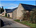
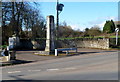
Walford Court Barns, Walford
Former farm buildings converted to residential use, located near the village church and the B4234.
Image: © Jaggery
Taken: 24 Feb 2012
0.01 miles
2
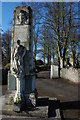
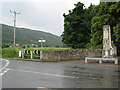
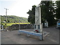
Walford War Memorial
Walford War Memorial stands at the entrance to the village church. The trees in the background line a remembrance road, one lime tree was planted for every man lost in the war from the parish, there are 24 in total and each has a stone slab at its base with the details of the serviceman for whom it was planted to commemorate.
Image: © Philip Halling
Taken: 30 Mar 2008
0.04 miles
3
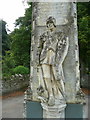
Grim reminder of war
The statue on the war memorial at Walford.
The figure has his foot on the head of a slain dragon.
Image: © Jonathan Billinger
Taken: 18 Sep 2008
0.04 miles
5
Criminals Beware! notice, Walford, Herefordshire
Text on the West Mercia Police notice on display in February 2023 includes
"THIS AREA IS PROTECTED BY SMARTWATER" and "Our community's property is
security marked and we work with police to prevent crime".
Image: © Jaggery
Taken: 5 Feb 2023
0.04 miles
7
War memorial, Walford
Designed by Gilbert Boulton https://sculpture.gla.ac.uk/view/person.php?id=ann_1326802926&search=stone
Image: © Jonathan Thacker
Taken: 17 Sep 2020
0.05 miles
8
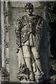
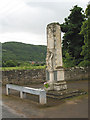
War Memorial, Walford
Figure on the War Memorial at the entrance to Walford church.
Image: © Philip Halling
Taken: 8 Aug 2009
0.05 miles
9
Walford War Memorial
Located near the entrance to the village church, opposite a 100 degree bend in the B4234.
Image: © Jaggery
Taken: 24 Feb 2012
0.05 miles
10
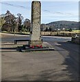
West side of Walford War Memorial, Herefordshire
Located between the B4234 (ahead) and the entrance to St Michael & All Angels churchyard.
https://www.geograph.org.uk/photo/3575135 to the opposite side of Walford War Memorial which was Grade II Listed in 1987.
Image: © Jaggery
Taken: 5 Feb 2023
0.05 miles