IMAGES TAKEN NEAR TO
Ashperton, LEDBURY, HR8 2SF
Introduction
This page details the photographs taken nearby to HR8 2SF by members of the Geograph project.
The Geograph project started in 2005 with the aim of publishing, organising and preserving representative images for every square kilometre of Great Britain, Ireland and the Isle of Man.

There are currently over 7.5m images from over14,400 individuals and you can help contribute to the project by visiting https://www.geograph.org.uk
Image Map
Images are licensed for reuse under creativecommons.org/licenses/by-sa/2.0
Notes
- Clicking on the map will re-center to the selected point.
- The higher the marker number, the further away the image location is from the centre of the postcode.
Image Listing (13 Images Found)
Images are licensed for reuse under creativecommons.org/licenses/by-sa/2.0
Image
Details
Distance
1
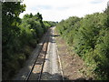
Ashperton station site
Nothing remains of the station or goods yard. Over a mile from the village they were intended to serve, the station was moribund from the 1930s as bus services and lorries started to serve farms and farmworkers more conveniently.
Image: © Peter Whatley
Taken: 3 Sep 2008
0.14 miles
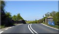
2
Dangerous bridge
Two sharp curves and a distinct hump make the A417 bridge over the Worcester-Ledbury railway trickier than might appear from the OS 1:50k map.
Image: © Peter Whatley
Taken: 3 Sep 2008
0.15 miles
3
Railway bridge at former Ashperton station
A417 crossing Ledbury to Hereford line
Image: © David Smith
Taken: 22 Apr 2015
0.15 miles
4
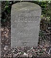
Old Milestone by the A417, The Castle, Ashperton Parish
Carved stone post by the A417, in parish of ASHPERTON (District), The Castle; 50m South of The Castle, on narrow verge against hedgerow, on West side of road. Ledbury stone, erected by the Leominster & Ledbury turnpike trust in the 19th century.
Inscription reads:- : TO / LEDBURY / 5 / MILES / LEOMINSTER / 17 / MILES :
Milestone Society National ID: HF_LBLM05.
Image: © M Faherty
Taken: 17 Apr 2008
0.15 miles
5

The Hereford to Worcester railway
This is a view eastwards towards Ledbury from the road bridge near the Trumpet.
Image: © Philip Halling
Taken: 22 Oct 2005
0.15 miles
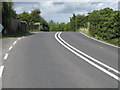
6
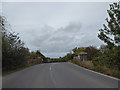
Road bridge over the railway
A rather sharp bend that can easily catch any driver out.
Image: © Jeremy Bolwell
Taken: 9 Oct 2019
0.15 miles
7
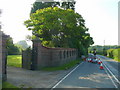
Entrance to The Castle
The traffic control is on account of the scaffolding currently on the building.
Image: © Jonathan Billinger
Taken: 23 Jul 2008
0.18 miles
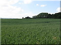
8
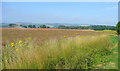
View south-west of the Station House
Rape field to the left is almost ready to harvest.
Image: © Jonathan Billinger
Taken: 23 Jul 2008
0.20 miles
9
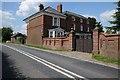
The Castle
The Castle, a house beside the A417 near Ashperton.
Image: © Philip Halling
Taken: 22 Jun 2014
0.20 miles