IMAGES TAKEN NEAR TO
Rushall, LEDBURY, HR8 2PE
Introduction
This page details the photographs taken nearby to HR8 2PE by members of the Geograph project.
The Geograph project started in 2005 with the aim of publishing, organising and preserving representative images for every square kilometre of Great Britain, Ireland and the Isle of Man.

There are currently over 7.5m images from over14,400 individuals and you can help contribute to the project by visiting https://www.geograph.org.uk
Image Map
Images are licensed for reuse under creativecommons.org/licenses/by-sa/2.0
Notes
- Clicking on the map will re-center to the selected point.
- The higher the marker number, the further away the image location is from the centre of the postcode.
Image Listing (15 Images Found)
Images are licensed for reuse under creativecommons.org/licenses/by-sa/2.0
Image
Details
Distance
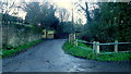
1
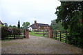
Converted farm building in Rushall
Between 1939 and November 1979 when it closed due to low usage, this building was a youth hostel. I understand the youth hostel occupied the upper floor, whilst the ground floor was a social club for the locals.
Image: © Philip Halling
Taken: 4 Apr 2017
0.05 miles
3
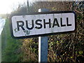
Rushall sign
Approaching the hamlet from the direction of Kynaston.
Image: © Jonathan Billinger
Taken: 21 Dec 2015
0.11 miles
5
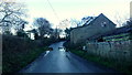
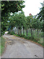
Rushall Lane at Cockyard Farm
Footpath heading north and east from this point.
The deep shade of a December afternoon once the sun has dipped below the Marcle Ridge.
Image: © Jonathan Billinger
Taken: 21 Dec 2015
0.19 miles
6
Farm track and footpath
At Cockyard Farm, Rushall. The path ascends the eastern slope of the Marcle Ridge.
Image: © Jonathan Billinger
Taken: 21 Dec 2015
0.19 miles
7
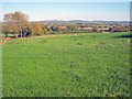
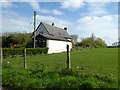
Farmland east of Rushall
From the lane near Cockyard Farm, looking east towards the Malvern Hills in the distance. Some geese investigating the new pond dug at the bottom of this field.
Image: © Trevor Rickard
Taken: 17 Oct 2010
0.19 miles
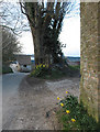
8
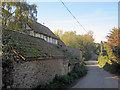
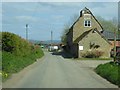
Lane at Rushall
Narrow lane heading north near a rather dilapidated cottage next to Cockyard Farm.
Image: © Trevor Rickard
Taken: 17 Oct 2010
0.20 miles