IMAGES TAKEN NEAR TO
Much Marcle, LEDBURY, HR8 2NJ
Introduction
This page details the photographs taken nearby to HR8 2NJ by members of the Geograph project.
The Geograph project started in 2005 with the aim of publishing, organising and preserving representative images for every square kilometre of Great Britain, Ireland and the Isle of Man.

There are currently over 7.5m images from over14,400 individuals and you can help contribute to the project by visiting https://www.geograph.org.uk
Image Map
Images are licensed for reuse under creativecommons.org/licenses/by-sa/2.0
Notes
- Clicking on the map will re-center to the selected point.
- The higher the marker number, the further away the image location is from the centre of the postcode.
Image Listing (8 Images Found)
Images are licensed for reuse under creativecommons.org/licenses/by-sa/2.0
Image
Details
Distance
1
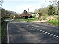
Bodenham Farm
Bodenham Farm viewed from the A449 to the south of Much Marcle.
Image: © Philip Halling
Taken: 30 Mar 2021
0.02 miles
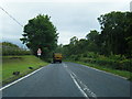
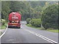
3
Entrance to Bodenham Farm
Taken on the A449, with bends on the road that approaches Much Marcle. Bodenham Farm is run as a Bed and Breakfast establishment.
Image: © Clint Mann
Taken: 18 Jul 2016
0.02 miles
4
Bodenham Farmhouse
Bodenham Farmhouse, a late 18th century Grade II listed https://historicengland.org.uk/listing/the-list/list-entry/1303037 farmhouse viewed from the passing A449.
Image: © Philip Halling
Taken: 30 Mar 2021
0.05 miles
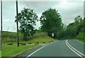
5
A449 near Homme House
The A449 starts to snake through the hills between Much Marcle and Ross-on-Wye.
Image: © J Whatley
Taken: 22 Sep 2010
0.09 miles
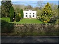
6
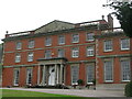
Homme House at Much Marcle
Fine house and garden
Image: © David M Clark
Taken: 12 Sep 2013
0.10 miles
7
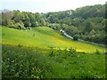
The A449 near Much Marcle
The A449 passing through a valley of farm and woodland at Bodenham Bank near Much Marcle.
Image: © Philip Halling
Taken: 30 May 2021
0.13 miles
8
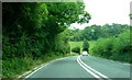
Road dip and bend on A449
Approaching Bodenham Farm
Image: © Clint Mann
Taken: 18 Jul 2016
0.22 miles