IMAGES TAKEN NEAR TO
Gloucester Road, LEDBURY, HR8 2JB
Introduction
This page details the photographs taken nearby to Gloucester Road, HR8 2JB by members of the Geograph project.
The Geograph project started in 2005 with the aim of publishing, organising and preserving representative images for every square kilometre of Great Britain, Ireland and the Isle of Man.

There are currently over 7.5m images from over14,400 individuals and you can help contribute to the project by visiting https://www.geograph.org.uk
Image Map
Images are licensed for reuse under creativecommons.org/licenses/by-sa/2.0
Notes
- Clicking on the map will re-center to the selected point.
- The higher the marker number, the further away the image location is from the centre of the postcode.
Image Listing (6 Images Found)
Images are licensed for reuse under creativecommons.org/licenses/by-sa/2.0
Image
Details
Distance
1
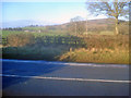
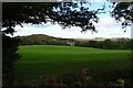
Farmland north of the A417
Looking north across the main road towards Woodfields Farm on the left and the wooded hillside at Clencher's Mill on the right.
Image: © Trevor Rickard
Taken: 1 Jan 2010
0.09 miles
2
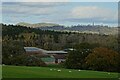
Woodfield Farm
Woodfield Farm with the Malvern Hills on the distance, the British Camp on the Herefordshire Beacon is on the left and the obelisk in Eastnor Park on the right.
Image: © Philip Halling
Taken: 22 Oct 2020
0.11 miles
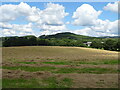
3
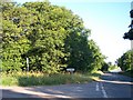
Brand Oak Coppice
At the junction of the A417 Gloucester to Ledbury road and the road to Donnington,
Image: © Bob Embleton
Taken: 21 Jul 2005
0.12 miles
4
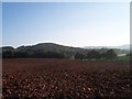
Woodfield's Farm
With Clencher's Hill behind and British camp on the Malvern Hills in the far distance.
Image: © Bob Embleton
Taken: 21 Jul 2005
0.12 miles
5
View to Woodfields Farm
View to Woodfields Farm near Bromesberrow. The Malvern Hills can be seen in the distance on the right.
Image: © Philip Halling
Taken: 22 Oct 2020
0.15 miles
6
Cut silage field near Woodfield Farm
Off the A417.
Image: © JThomas
Taken: 10 Aug 2021
0.22 miles