IMAGES TAKEN NEAR TO
Bromsberrow, LEDBURY, HR8 1SF
Introduction
This page details the photographs taken nearby to HR8 1SF by members of the Geograph project.
The Geograph project started in 2005 with the aim of publishing, organising and preserving representative images for every square kilometre of Great Britain, Ireland and the Isle of Man.

There are currently over 7.5m images from over14,400 individuals and you can help contribute to the project by visiting https://www.geograph.org.uk
Image Map
Images are licensed for reuse under creativecommons.org/licenses/by-sa/2.0
Notes
- Clicking on the map will re-center to the selected point.
- The higher the marker number, the further away the image location is from the centre of the postcode.
Image Listing (18 Images Found)
Images are licensed for reuse under creativecommons.org/licenses/by-sa/2.0
Image
Details
Distance
1
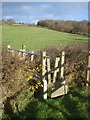
Stile near Toney's Farm
Looking northwards across the ditch stile. Toney's Coppice ahead to the right.
Image: © Trevor Rickard
Taken: 3 Dec 2007
0.08 miles
2
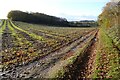
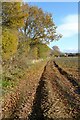
Farmland at Bromesberrow
A footpath follows the hedgerow on the right. The field has had stick beans growing here during this season and there is a considerable amount of polythene littering the field.
Image: © Philip Halling
Taken: 4 Dec 2021
0.13 miles
3
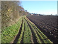
Footpath to Toney's Farm
Just past the right-angles bend the path follows the north side of a ploughed field with the farmhouse ahead.
Image: © Trevor Rickard
Taken: 3 Dec 2007
0.14 miles
4

Track between Toney's Farm and Toney's Coppice
May Hill can be seen in the distance on the horizon.
Image: © Philip Halling
Taken: 4 Dec 2021
0.15 miles
5
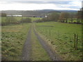
Track to Toney's Farm
As it exits Toney's Coppice, the track heads southwards to Toney's Farm just ahead. May Hill on the horizon.
Image: © Trevor Rickard
Taken: 3 Dec 2007
0.15 miles
6
Field headland footpath
Trees in a hedgerow approaching Toney's Farm near Bromesberrow.
Image: © Philip Halling
Taken: 4 Dec 2021
0.17 miles
7
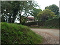
Toney's Cottage (Bromesberrow)
Here is the timber-framed Toney's Cottage in Bromesberrow, taken from the lane that rises upwards to the small car park for people visiting Chase End Hill.
Image: © Fabian Musto
Taken: 10 Sep 2020
0.17 miles
8

Track approaching Toney's Coppice
Track and footpath between Toney's Farm and Toney's Coppice.
Image: © Philip Halling
Taken: 4 Dec 2021
0.17 miles
9
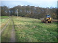
Track to Howler's Heath
View northwards and uphill along the track as it enters Toney's Coppice.
Image: © Trevor Rickard
Taken: 3 Dec 2007
0.18 miles
10
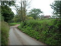
Lane by Toney's Cottage (Bromesberrow)
This country lane that rises upwards to the small car park by Chase End Hill passes the timber-framed Toney's Cottage building.
Image: © Fabian Musto
Taken: 10 Sep 2020
0.19 miles