IMAGES TAKEN NEAR TO
Bromsberrow, LEDBURY, HR8 1SE
Introduction
This page details the photographs taken nearby to HR8 1SE by members of the Geograph project.
The Geograph project started in 2005 with the aim of publishing, organising and preserving representative images for every square kilometre of Great Britain, Ireland and the Isle of Man.

There are currently over 7.5m images from over14,400 individuals and you can help contribute to the project by visiting https://www.geograph.org.uk
Image Map
Images are licensed for reuse under creativecommons.org/licenses/by-sa/2.0
Notes
- Clicking on the map will re-center to the selected point.
- The higher the marker number, the further away the image location is from the centre of the postcode.
Image Listing (123 Images Found)
Images are licensed for reuse under creativecommons.org/licenses/by-sa/2.0
Image
Details
Distance
1
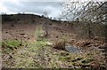
Pool on Chase End Hill
On the extensive common land on the western slopes of the hill.
Image: © Bob Embleton
Taken: 4 Apr 2010
0.04 miles
2
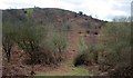
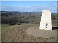
Path on the side of Chase End Hill
Although the hill is the lowest of the Malvern Hills range the common land in which it sits (and the public can explore) is quite extensive, covering some 27 hectares.
The trig point can be seen on the peak.
Image: © Bob Embleton
Taken: 4 Apr 2010
0.06 miles
3
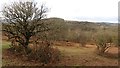
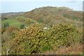
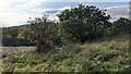
On Chase End Hill
The common is reverting to woodland due to reduced grazing, it's just the rabbits and deer here.
I was disgusted at the behaviour of the Malvern Conservators during the 2001 foot and mouth outbreak. When they eventually "opened" the commons, I found out that there was no livestock there at all. A real case of Emperor's Clothes. Not quite as moronic as closing the canal footpath in Wednesfield though. Beware of "Something Must Be Done" and always be prepared to ask questions.
Image: © Richard Webb
Taken: 28 Dec 2011
0.07 miles
4
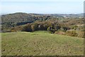
A view over Eastnor
A view over Eastnor from Chase End Hill, the castle can be seen in the distance.
Image: © Philip Halling
Taken: 30 Oct 2017
0.07 miles
5
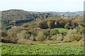
Woodland at Eastnor
Woodland at Eastnor viewed from Chase End Hill. Eastnor Castle can be seen to the right in the distance.
Image: © Philip Halling
Taken: 30 Oct 2017
0.07 miles
6
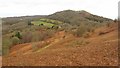
On Chase End Hill
A view towards Ragged Stone Hill from the southern side of Chase End Hill.
Image: © Richard Webb
Taken: 28 Dec 2011
0.07 miles
7
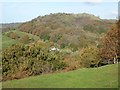
Ragged Stone Hill
Ragged Stone Hill and the hamlet of Whiteleaved Oak viewed from Chase End Hill.
Image: © Philip Halling
Taken: 30 Oct 2017
0.08 miles
8
Raged Stone Hill
Raged Stone Hill viewed from Chase End Hill.
Image: © Philip Halling
Taken: 30 Oct 2017
0.08 miles
10
Trig point on Chase End Hill - 3
View north-west over Pendock's Grove towards Eastnor Castle. Frith Hill on the horizon.
Image: © Trevor Rickard
Taken: 30 Jan 2008
0.09 miles