IMAGES TAKEN NEAR TO
Bosbury, LEDBURY, HR8 1QQ
Introduction
This page details the photographs taken nearby to HR8 1QQ by members of the Geograph project.
The Geograph project started in 2005 with the aim of publishing, organising and preserving representative images for every square kilometre of Great Britain, Ireland and the Isle of Man.

There are currently over 7.5m images from over14,400 individuals and you can help contribute to the project by visiting https://www.geograph.org.uk
Image Map
Images are licensed for reuse under creativecommons.org/licenses/by-sa/2.0
Notes
- Clicking on the map will re-center to the selected point.
- The higher the marker number, the further away the image location is from the centre of the postcode.
Image Listing (5 Images Found)
Images are licensed for reuse under creativecommons.org/licenses/by-sa/2.0
Image
Details
Distance
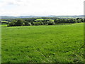
1
Fox Hill
The Herefordshire Trail follows a footpath across this field at Fox Hill, en route from Fromes Hill to Bosbury.
Image: © Philip Halling
Taken: 11 Mar 2012
0.13 miles
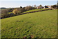
2
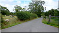
Entrance to property near Fromes Hill
Entrance to property off the road from Fromes Hill to Bosbury.
Image: © Philip Halling
Taken: 29 Oct 2005
0.14 miles
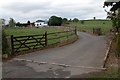
3
Field on Fox Hill
A footpath crosses this field which may have been an orchard in the past.
Image: © Philip Halling
Taken: 11 Mar 2012
0.22 miles
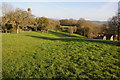
4
Lane to Woodlow and Woodlow Farm
Also shows two typical Herefordshire land uses; sheep and orchards.
Image: © Jonathan Billinger
Taken: 10 Aug 2015
0.23 miles