IMAGES TAKEN NEAR TO
Bosbury, LEDBURY, HR8 1QG
Introduction
This page details the photographs taken nearby to HR8 1QG by members of the Geograph project.
The Geograph project started in 2005 with the aim of publishing, organising and preserving representative images for every square kilometre of Great Britain, Ireland and the Isle of Man.

There are currently over 7.5m images from over14,400 individuals and you can help contribute to the project by visiting https://www.geograph.org.uk
Image Map
Images are licensed for reuse under creativecommons.org/licenses/by-sa/2.0
Notes
- Clicking on the map will re-center to the selected point.
- The higher the marker number, the further away the image location is from the centre of the postcode.
Image Listing (7 Images Found)
Images are licensed for reuse under creativecommons.org/licenses/by-sa/2.0
Image
Details
Distance
1
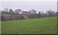
Woodlow Farm
Looking north from the start of the lane to Dodd's Mill.
Image: © Bob Embleton
Taken: 5 Jan 2006
0.03 miles
3
Farmland in the Leadon valley
Farmland opposite Notehouse Farm in the Leadon valley.
Image: © Philip Halling
Taken: 23 Aug 2021
0.18 miles
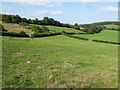
5
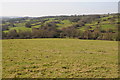
The Leadon Valley
The River Leadon flows through Herefordshire and then through Gloucestershire to its confluence with the River Severn to the north of Gloucester. Here it is pictured in its upper reaches to the north of Bosbury. View across the valley from Beacon Hill towards Woodlow Farm.
Image: © Philip Halling
Taken: 11 Mar 2012
0.23 miles
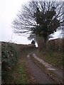
6
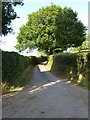
Lane to Dodd's Mill
This lane to Dodd's Mill is also a traffic free cycle route. This is a same subject as the first picture uploaded in this grid square Image
Image: © Philip Halling
Taken: 23 Aug 2021
0.24 miles
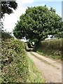
7
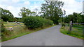
Lane to Woodlow and Woodlow Farm
Also shows two typical Herefordshire land uses; sheep and orchards.
Image: © Jonathan Billinger
Taken: 10 Aug 2015
0.24 miles