IMAGES TAKEN NEAR TO
Bosbury, LEDBURY, HR8 1QE
Introduction
This page details the photographs taken nearby to HR8 1QE by members of the Geograph project.
The Geograph project started in 2005 with the aim of publishing, organising and preserving representative images for every square kilometre of Great Britain, Ireland and the Isle of Man.

There are currently over 7.5m images from over14,400 individuals and you can help contribute to the project by visiting https://www.geograph.org.uk
Image Map
Images are licensed for reuse under creativecommons.org/licenses/by-sa/2.0
Notes
- Clicking on the map will re-center to the selected point.
- The higher the marker number, the further away the image location is from the centre of the postcode.
Image Listing (10 Images Found)
Images are licensed for reuse under creativecommons.org/licenses/by-sa/2.0
Image
Details
Distance
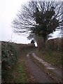
3
Side of Beacon Hill
Summer 2008's rainfall appears to be accelerating erosion of tractor ruts.
Image: © Peter Whatley
Taken: 3 Sep 2008
0.13 miles
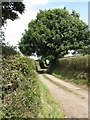
4
Lane to Dodd's Mill
This lane to Dodd's Mill is also a traffic free cycle route. This is a same subject as the first picture uploaded in this grid square Image
Image: © Philip Halling
Taken: 23 Aug 2021
0.15 miles
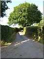
5
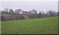
Woodlow Farm
Looking north from the start of the lane to Dodd's Mill.
Image: © Bob Embleton
Taken: 5 Jan 2006
0.18 miles
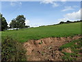
6
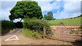
Dead end lane to Dodd's Mill
To the right on the slope of Beacon Hill is some dairy cattle.
Image: © Jonathan Billinger
Taken: 10 Aug 2015
0.18 miles
7
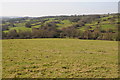
The Leadon Valley
The River Leadon flows through Herefordshire and then through Gloucestershire to its confluence with the River Severn to the north of Gloucester. Here it is pictured in its upper reaches to the north of Bosbury. View across the valley from Beacon Hill towards Woodlow Farm.
Image: © Philip Halling
Taken: 11 Mar 2012
0.22 miles
8
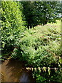
The River Leadon, 1
Looking upstream.
Image: © Jonathan Billinger
Taken: 10 Aug 2015
0.24 miles
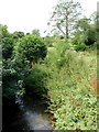
9
The River Leadon, 2
Looking downstream; the river is juvenile here and the modest vegetation almost meets over.
Image: © Jonathan Billinger
Taken: 10 Aug 2015
0.25 miles
10
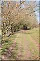
Track in the Leadon Valley
In places such as here this farm track and public byway resemble the bed of a disused railway.
Image: © Philip Halling
Taken: 11 Mar 2012
0.25 miles