IMAGES TAKEN NEAR TO
Coddington, LEDBURY, HR8 1JW
Introduction
This page details the photographs taken nearby to HR8 1JW by members of the Geograph project.
The Geograph project started in 2005 with the aim of publishing, organising and preserving representative images for every square kilometre of Great Britain, Ireland and the Isle of Man.

There are currently over 7.5m images from over14,400 individuals and you can help contribute to the project by visiting https://www.geograph.org.uk
Image Map
Images are licensed for reuse under creativecommons.org/licenses/by-sa/2.0
Notes
- Clicking on the map will re-center to the selected point.
- The higher the marker number, the further away the image location is from the centre of the postcode.
Image Listing (9 Images Found)
Images are licensed for reuse under creativecommons.org/licenses/by-sa/2.0
Image
Details
Distance
1
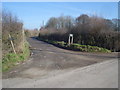
Entrance to Riddings Farm
View north-east from the lane to the farm entrance, complete with farm sign, newspaper holder and footpath finger post.
Image: © Trevor Rickard
Taken: 11 Feb 2008
0.06 miles
2
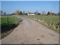
Entrance to The Riddings Farm
Entrance and road to The Riddings Farm.
Image: © Philip Halling
Taken: 22 Nov 2020
0.06 miles
3
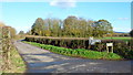
Farm road and footpath to Riddings Farm
An attractive area of farmland and scattered woods north-east of Bosbury.
Image: © Jonathan Billinger
Taken: 14 Nov 2014
0.06 miles
4
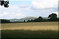
Pasture near Stoneyard Green
Looking towards the Malvern Hills with the large Worcestershire Beacon in the centre. North Hill and Sugarloaf Hill are to the left.
Image: © Bob Embleton
Taken: 2 Aug 2007
0.14 miles
5
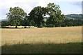
Cereal land and oaks
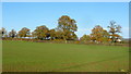
Riddings Farm can be seen beyond the trees.
Image: © Jonathan Billinger
Taken: 14 Nov 2014
0.15 miles
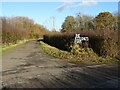
6
Entrance road at Winsordine
View north to the two houses off the Riddings Farm lane.
Image: © Trevor Rickard
Taken: 11 Feb 2008
0.18 miles
7
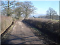
Lane to Riddings Farm
View north-east with the Worcestershire Beacon on the right. The lane is muddy, partly due to the recently cleared drainage ditches on either side.
Image: © Trevor Rickard
Taken: 11 Feb 2008
0.22 miles
8
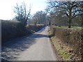
Lane near Stoneyard Green
View south-west towards the sharp bend.
Image: © Trevor Rickard
Taken: 11 Feb 2008
0.23 miles
9
Pasture near Bosbury House
Taken from near the entrance to Bosbury house not far from Stoneyard Green. Looking towards Coddington. The church spire is just visible above the trees with Oyster Hill beyond.
Image: © Bob Embleton
Taken: 2 Aug 2007
0.24 miles